

Design of spatial database on natural zoning for highway in China
Article Text (Baidu Translation)
-
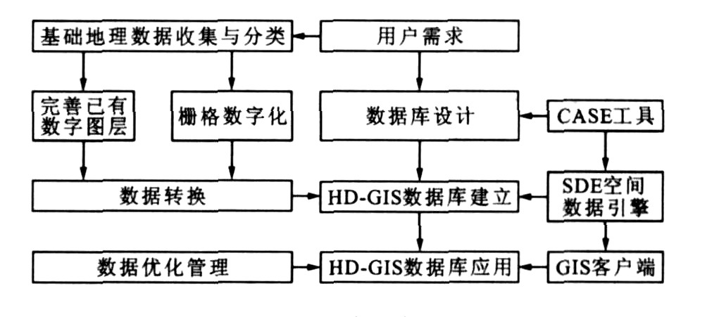
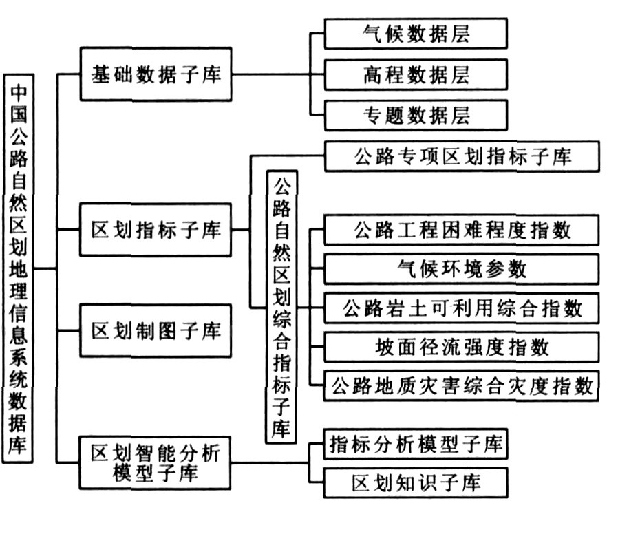
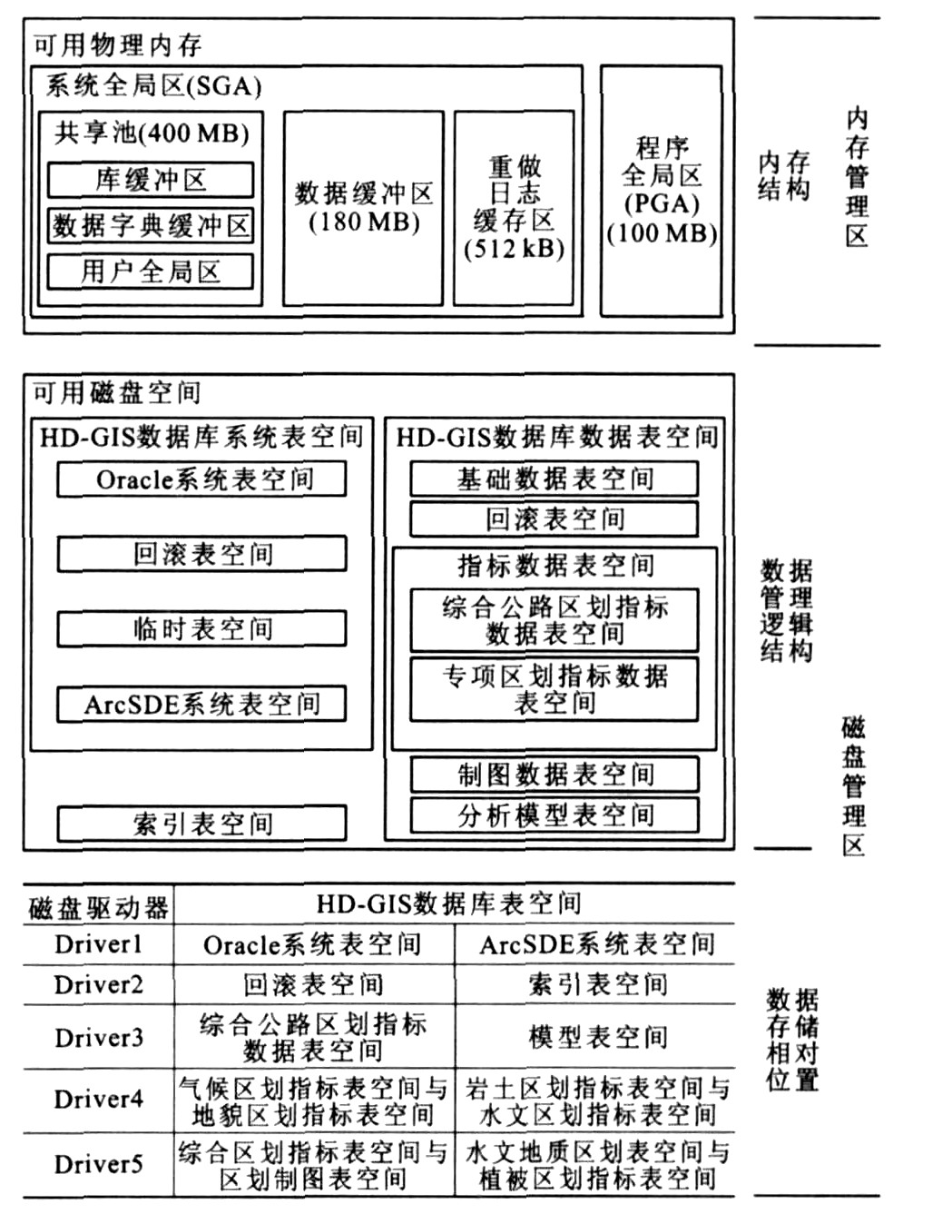
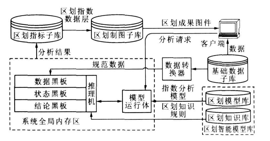
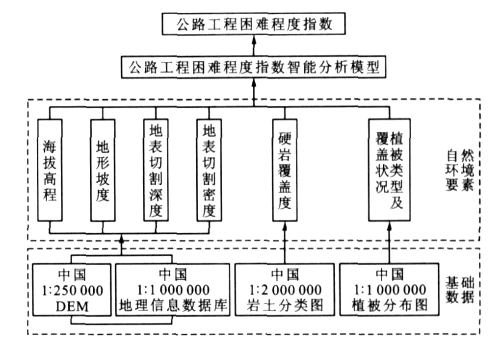
摘要: 为了实现中国公路自然区划的定量化与自动化, 从概念、逻辑和物理层面进行了中国公路自然区划空间数据库结构设计, 利用空间数据引擎技术, 借助大型关系型数据库管理系统对数据存储与管理功能建立了空间数据库, 基于此数据库, 利用多因子权重法计算了公路工程困难程度指数。分析结果表明: 海拔高程、地形坡度、地表切割深度、地表切割密度、硬岩覆盖度以及植被覆盖度是影响公路工程困难程度指数分布的主要因素, 根据困难度指数分布图, 从地貌角度直观地反映了中国不同地区公路建设的困难程度。可见此数据库系统的建立实现了公路自然区划的量化分析模式, 解决了海量空间数据的存储与管理问题。Abstract: In order to realize the quantification and automatization on natural zoning for highway in China(NZHC), the spatial database structure of NZHC was designed from the concept, logic and physical aspects, the technology of spatial data engine was used, the spatial database was built based on the data storage and management function of large-scale relationship database management system, the difficult degree indices of highway engineering(DDIHE) were calculated by using multi-factor weight method based on the database. Analysis result shows that altitude, terrain slope, landform incision depth, landform incision density, hard rock coverage and vegetation coverage are main factors affecting DDIHE distribution, the map of DDIHE can visually reflect DDIHE in different regions from the view of physiognomy. Obviously, the establishment of the database realizes the quantification analysis mode of NZHC, solves the storage and management problem of mass spatial data.
-

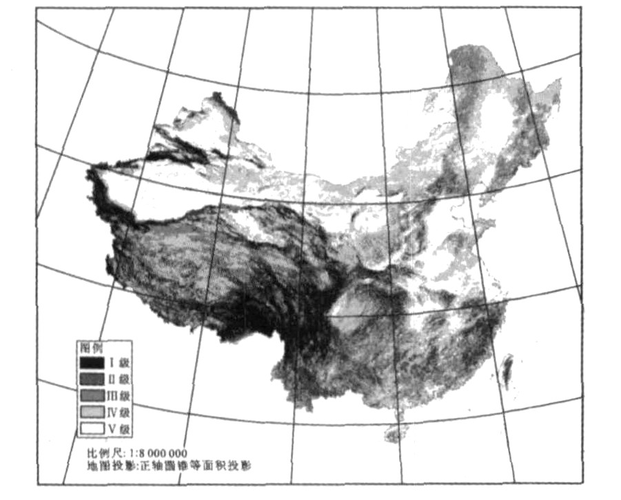
图 7 公路工程困难程度指数分布
Figure 7. Distribution of difficult degree indices for highway engineering
表 1 影响因子标度分值取值
Table 1. Scaling point values of factors
困难程度影响因子 困难度等级与标度分值 无 轻度 中度 严重 极严重 0 1 3 6 10 平均海拔高程/m ≤1 000 1 000~1 500 1 500~2 500 2 500~3 000 > 3 000 地面平均坡度/(°) ≤3 3~6 6~10 10~20 > 20 地表切割密度/(km·km-2) ≤0.10 0.10~0.30 0.30~0.55 0.55~0.80 > 0.80 地表切割深度/m ≤100 100~200 200~500 500~1 000 > 1 000 硬岩覆盖度/% 0 0~30 30~50 50~70 > 70 植被类型 无植被 耕地 草 灌 林  下载: 导出CSV
表 2 影响因子权重系数
Table 2. Weight coefficients of factors
影响因子 平均海拔高程 平均地面坡度 切割密度 切割深度 硬岩覆盖度 植被类型 合计 权重系数 0.160 0.161 0.206 0.210 0.149 0.114 1.000
下载: 导出CSV
表 3 公路工程困难度等级
Table 3. Classifications of difficult degrees for highway engineering
困难度指数 ≤1 1~2 2~4 4~6 > 6 工程难度 无 较小 一般 较大 极大 困难度等级 Ⅴ Ⅳ级 Ⅲ级 Ⅱ级 Ⅰ级
下载: 导出CSV
-
[1] Gao Y, Alexander J, Tipping R. Karst database development in Minnesota: design and data assembly[J]. Environmental Geology, 2005, 47(8): 1072-1082. doi: 10.1007/s00254-005-1240-3 [2] 李晔, 姚祖康. 基于地理信息系统的公路设施空间数据库概念模型[J]. 中国公路学报, 2000, 13(3): 9-11. https://www.cnki.com.cn/Article/CJFDTOTAL-ZGGL200003002.htmLi Ye, Yao Zu-kang. GIS-based highway facilities spatial database conceptual model[J]. China Journal of Highway and Transport, 2000, 13(3): 9-11. (in Chinese) https://www.cnki.com.cn/Article/CJFDTOTAL-ZGGL200003002.htm [3] 暨育雄, 阚胜男, 孙立军. 基于GIS的机场道面管理系统[J]. 交通运输工程学报, 2004, 4(1): 70-74. http://transport.chd.edu.cn/article/id/200401018Ji Yu-xiong, Kan Sheng-nan, Sun Li-jun. Airport pavement management system based on GIS[J]. Journal of Traffic and Transportation Engineering, 2004, 4(1): 70-74. (in Chinese). http://transport.chd.edu.cn/article/id/200401018 [4] 宣登殿, 胡大伟, 蔺宏良. 基于GIS的城市物流配送系统规划方法[J]. 长安大学学报: 自然科学版, 2006, 26(2): 84-87. https://www.cnki.com.cn/Article/CJFDTOTAL-XAGL200602020.htmXuan Deng-dian, Hu Da-wei, Lin Hong-liang. Planning method of city logistics delivery system based on GIS[J]. Journal of Chang'an University: Natural Science Edition, 2006, 26(2): 84-87. (in Chinese) https://www.cnki.com.cn/Article/CJFDTOTAL-XAGL200602020.htm [5] Devillers R, Bedard Y, Jeansoulin R. Multidi mensional management of geospatial data quality information for its dynamic use within GIS[J]. Photogrammetric Engineering and Remote Sensing, 2005, 71(2): 205-215. doi: 10.14358/PERS.71.2.205 [6] 朱庆, 吴波, 钟正. 三维GIS与公路CAD的集成[J]. 中国公路学报, 2006, 19(4): 1-6. https://www.cnki.com.cn/Article/CJFDTOTAL-ZGGL200604000.htmZhu Qing, Wu Bo, Zhong Zheng. Integration of 3-D GIS and highway CAD[J]. China Journal of Highway and Transport, 2006, 19(4): 1-6. (in Chinese) https://www.cnki.com.cn/Article/CJFDTOTAL-ZGGL200604000.htm [7] 赵仲华, 赵黎明, 郑江波. 基于地理信息系统的公路管理信息系统[J]. 长安大学学报: 自然科学版, 2005, 25(1): 69-72. https://www.cnki.com.cn/Article/CJFDTOTAL-XAGL200501017.htmZhao Zhong-hua, Zhao Li-ming, Zheng Jiang-bo. Highway management information system based on GIS[J]. Journal of Chang'an University: Natural Science Edition, 2005, 25(1): 69-72. (in Chinese) https://www.cnki.com.cn/Article/CJFDTOTAL-XAGL200501017.htm [8] Magcale M, Delgado M, Villarin J. A GIS-based model to improve estimation of aboveground biomass of secondary forests in the Philippines[J]. Journal of Tropical Forest Science, 2006, 18(1): 8-21. [9] 张小荣. 甘肃省公路自然区划研究报告[R]. 兰州: 甘肃省交通规划勘查设计院, 2005. [10] Bender O, Boehmer HJ, Jens D. Using GIS to analyze long-term cultural landscape change in Southern Germany[J]. Landscape and Urban Planning, 2005, 70(1): 111-125. -

 点击查看大图
图(7) / 表(3)
计量
- 文章访问数: 469
- HTML全文浏览量: 198
- PDF下载量: 787
- 被引次数: 0
