

Extraction method of main routes in South China Sea based on spatial cluster analysis
Article Text (Baidu Translation)
-
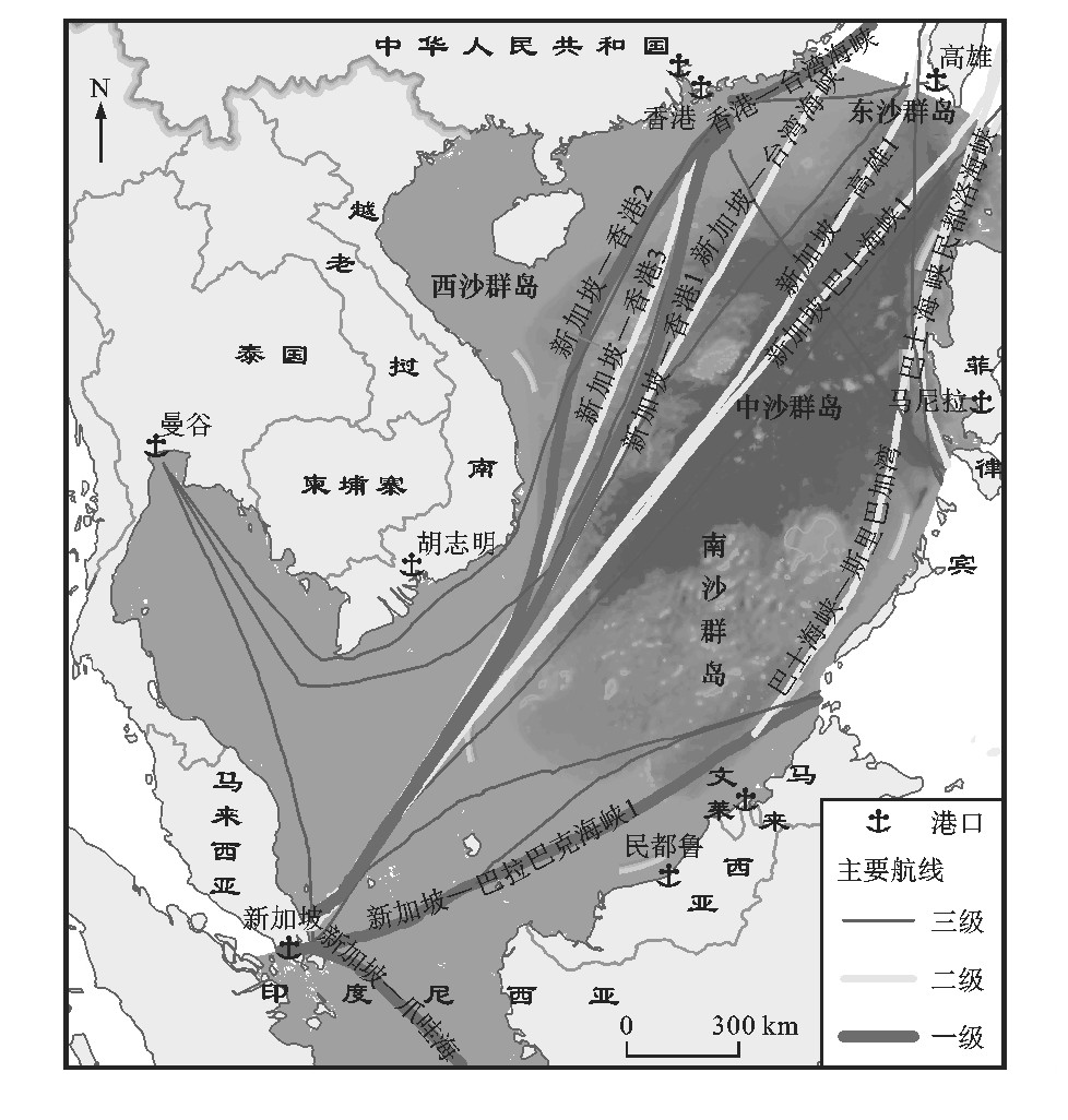
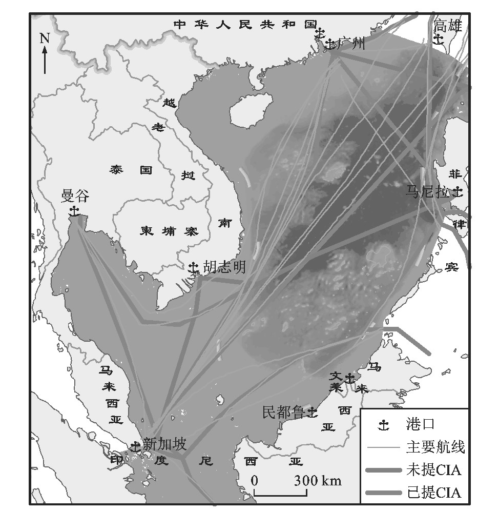
摘要: 提出了一种基于空间聚类分析的南海主要航线提取方法, 利用2001~2014年VOSClim舰船数据, 通过航线生成、航线聚类、聚类中心线提取得到了南海主要航线提取与分级结果, 将提取结果与美国中央情报局所得航线进行对比, 对南海主要航线分布特征进行分析。分析结果表明: 提取出21条南海主要航线, 一~三级航线分别有5、6、10条; 在21条南海主要航线中, 经过南沙群岛周边海域的航线多达14条; 在5条一级航线中, 分布在南海北部、西部和南部的航线分别有1、2、2条; 重要性指数由高到低的前5条航线依次为新加坡—香港、香港—台湾海峡、新加坡—巴拉巴克海峡、新加坡—巴士海峡、新加坡—高雄航线; 南海主要航线以西南—东北向为主, 新加坡、香港为南海最重要的2个交通枢纽。Abstract: An extraction method of main routes in South China Sea based on spatial cluster analysis was proposed.The VOSClim ship data in 2001-2014 were used to obtain the extraction and classification result of main routes in South China Sea through route generation, route cluster and cluster centerline extraction.Extraction result was compared with the routes of American Central Intelligence Agency.The distribution characteristics of main routes in South China Sea were analyzed.Analysis result shows that 21 main routes in South China Sea are extracted.There are 5, 6and 10 routes for classes one, two and three respectively.Among 21 main routes in South China Sea, up to 14 routes go through the surrounding waters of Nansha Islands.Among 5routes of class one in South China Sea, 1, 2and 2routes are distributed at the northern, western and southern South China Sea respectively.The first five routes sorted by significance index from high to low are Singapore-Hong Kong, Hong Kong-Taiwan Strait, Singapore-Balabac Strait, Singapore-Bashi Strait and Singapore-Kaohsiung routes successively.The direction of main routes in South China Sea is mainly southwest-northeast.Singapore andHong Kong are two most important transportation hubs in South China Sea.
-
Key words:
- route /
- spatial cluster /
- VOSClim /
- centerline /
- classification /
- South China Sea
-

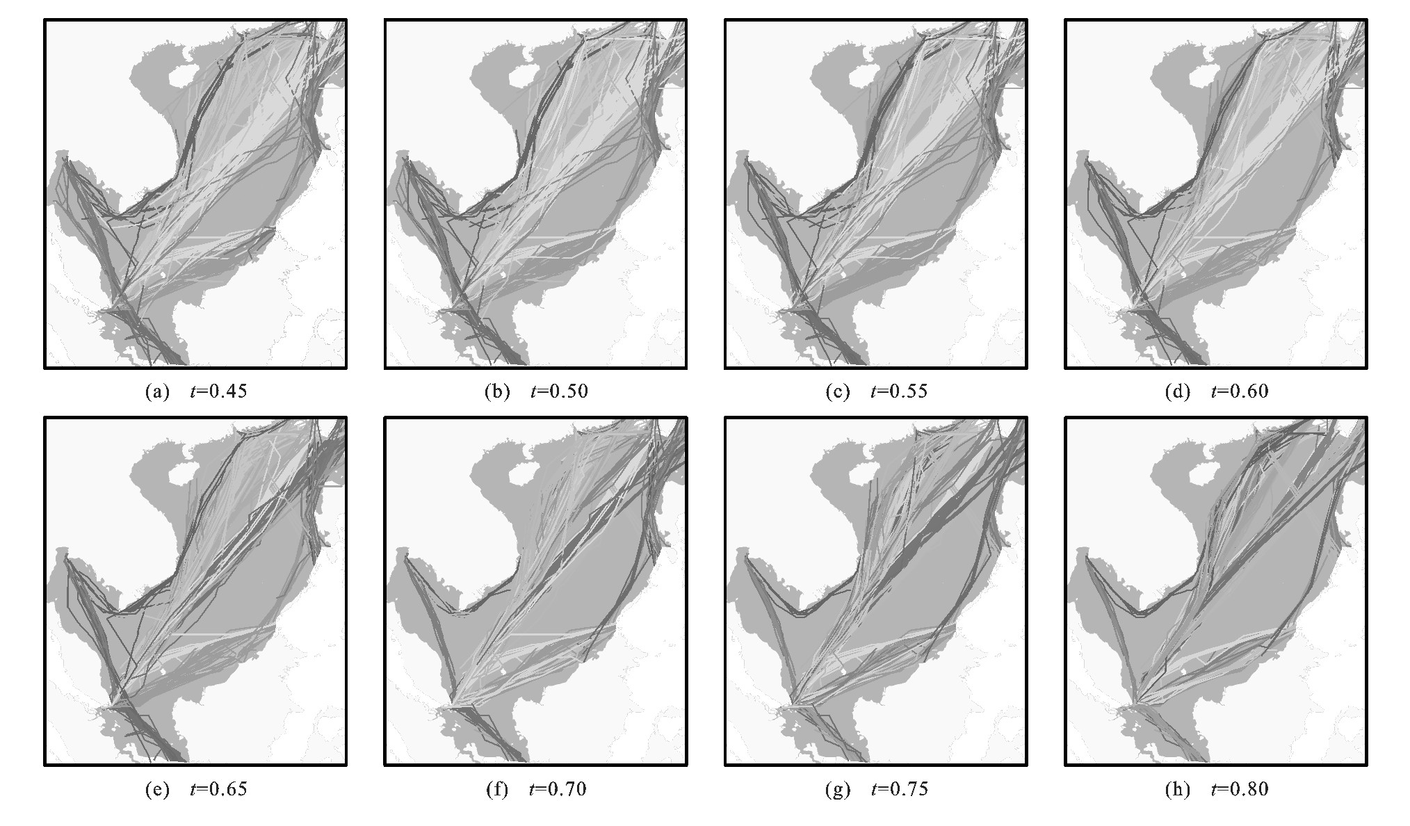
图 5 不同簇间相似性阈值的聚类结果
Figure 5. Clustering results with different similarity thresholds between clusters
-
[1] 王成金. 全球集装箱航运的空间组织网络[J]. 地理研究, 2008, 27(3): 636-648. doi: 10.3321/j.issn:1000-0585.2008.03.017WANG Cheng-jin. Spatial organization networks of world marine container transportation[J]. Geographical Research, 2008, 27(3): 636-648. (in Chinese). doi: 10.3321/j.issn:1000-0585.2008.03.017 [2] 陈万灵, 何传添. 海上丝绸之路的各方博弈及其经贸定位[J]. 区域经济, 2014(3): 74-83. https://www.cnki.com.cn/Article/CJFDTOTAL-REFO201403010.htmCHEN Wan-ling, HE Chuan-tian. Game between parties and economic orientation of the Maritime Silk Road[J]. Regional Economy, 2014(3): 74-83. (in Chinese). https://www.cnki.com.cn/Article/CJFDTOTAL-REFO201403010.htm [3] WANG Jia-sheng, LI Man-chun, LIU Yong-xue, et al. Safety assessment of shipping routes in the South China Sea based on the fuzzy analytic hierarchy process[J]. Safety Science, 2014, 62: 46-57. doi: 10.1016/j.ssci.2013.08.002 [4] HALPERN B S, WALBRIDGE S, SELKOE K A, et al. A global map of human impact on marine ecosystems[J]. Science, 2008, 319(5865): 948-952. doi: 10.1126/science.1149345 [5] 程传亮, 闫循堂. 船舶对海洋的污染及其治理措施[J]. 中国水运: 学术版, 2006, 6(7): 12-13. doi: 10.3969/j.issn.1006-7973-B.2006.07.005CHENG Chuan-liang, YAN Xun-tang. Ships to sea pollution and government measure[J]. China Water Tranport: Academic Version, 2006, 6(7): 12-13. (in Chinese). doi: 10.3969/j.issn.1006-7973-B.2006.07.005 [6] LAWRENCE M G, CRUTZEN P J. Influence of NOxemissions from ships on tropospheric photochemistry and climate[J]. Nature, 1999, 402(6758): 167-170. doi: 10.1038/46013 [7] 许欢, 刘伟, 张爽. 低碳经济下船舶航行速度选择[J]. 中国航海, 2012, 35(2): 98-101, 109. https://www.cnki.com.cn/Article/CJFDTOTAL-ZGHH201202023.htmXU Huan, LIU Wei, ZHANG Shuang. Choice of ship speed under low-carbon economy[J]. Navigation of China, 2012, 35(2): 98-101, 109. (in Chinese). https://www.cnki.com.cn/Article/CJFDTOTAL-ZGHH201202023.htm [8] 高宗江, 张英俊, 朱飞祥, 等. 远洋船舶避台航线设计算法[J]. 大连海事大学学报, 2013, 39(1): 39-42. doi: 10.3969/j.issn.1006-7736.2013.01.010GAO Zong-jiang, ZHANG Ying-jun, ZHU Fei-xiang, et al. Routing design method for ocean ship avoiding the typhoon[J]. Journal of Dalian Maritime University, 2013, 39(1): 39-42. (in Chinese). doi: 10.3969/j.issn.1006-7736.2013.01.010 [9] 李振福. 中国的北极航线机会和威胁分析[J]. 水运工程, 2009(8): 7-11, 15. doi: 10.3969/j.issn.1002-4972.2009.08.002LI Zhen-fu. Analysis of China's opportunities and threats on Arctic route[J]. Port and Waterway Engineering, 2009(8): 7-11, 15. (in Chinese). doi: 10.3969/j.issn.1002-4972.2009.08.002 [10] 巫蓓. 我国南海海域的海运安全评价[D]. 大连: 大连海事大学, 2013.WU Bei. Assessment of shipping traffic safety of the South China Sea[D]. Dalian: Dalian Maritime University, 2013. (in Chinese). [11] 陈万平, 陈仕平. 海盗防治与南海海上安全的保障[J]. 海洋开发与管理, 2012, 29(5): 62-66. https://www.cnki.com.cn/Article/CJFDTOTAL-HKGL201205017.htmCHEN Wan-ping, CHEN Shi-ping. Prevention of piracy and maritime safety guarantee of the South China Sea[J]. Ocean Development and Management, 2012, 29(5): 62-66. (in Chinese). https://www.cnki.com.cn/Article/CJFDTOTAL-HKGL201205017.htm [12] 肖潇, 邵哲平, 潘家财, 等. 基于AIS信息的船舶轨迹聚类模型及应用[J]. 中国航海, 2015, 38(2): 82-86. doi: 10.3969/j.issn.1000-4653.2015.02.020XIAO Xiao, SHAO Zhe-ping, PAN Jia-cai, et al. Ship trajectory clustering model based on AIS data and its application[J]. Navigation of China, 2015, 38(2): 82-86. (in Chinese). doi: 10.3969/j.issn.1000-4653.2015.02.020 [13] LIN Dong. Spatial analysis of ship routes for maritime security and safe navigation[D]. Halifax: Dalhousie University, 2008. [14] MORTON B, BLACKMORE G. South China Sea[J]. Marine Pollution Bulletin, 2001, 42(12): 1236-1263. doi: 10.1016/S0025-326X(01)00240-5 [15] 陈传波, 唐浩. 矢量图中绕过障碍物的最短路径算法研究[J]. 自动化技术与应用, 2003, 22(1): 34-36. doi: 10.3969/j.issn.1003-7241.2003.01.011CHEN Chuan-bo, TANG Hao. Algorithms for the shortest path rounding obstacles in vector graphics[J]. Techniques of Automation and Applications, 2003, 22(1): 34-36. (in Chinese). doi: 10.3969/j.issn.1003-7241.2003.01.011 [16] SCHRECK T, BERNARD J, VON LANDESBERGER T, et al. Visual cluster analysis of trajectory data with interactive Kohonen maps[J]. Information Visualization, 2009, 8(1): 14-29. doi: 10.1057/ivs.2008.29 [17] ANDRIENKO G, ANDRIENKO N, WROBEL S. Visual analytics tools for analysis of movement data[J]. ACM SIGKDD Explorations Newsletter, 2007, 9(2): 38-46. doi: 10.1145/1345448.1345455 [18] ANDRIENKO N, ANDRIENKO G. Visual analytics of movement: an overview of methods, tools and procedures[J]. Information Visualization, 2013, 12(1): 3-24. [19] XU Rui, WUNSCH D II. Survey of clustering algorithms[J]. IEEE Transactions on Neural Networks, 2005, 16(3): 645-678. [20] LEE J G, HAN Jia-wei, WHANG K Y. Trajectory clustering: apartition-and-group framework[C]//ACM. Proceedings of the 2007 ACM SIGMOD International Conference on Management of Data. New York: ACM, 2007: 593-604. [21] NANNI M, PEDRESCHI D. Time-focused clustering of trajectories of moving objects[J]. Journal of Intelligent Information Systems, 2006, 27(3): 267-289. [22] BOUIX S, SIDDIQI K, TANNENBAUM A. Flux driven automatic centerline extraction[J]. Medical Image Analysis, 2005, 9(3): 209-221. [23] CHEN Tie-ling, WANG Jin-fei, ZHANG Kai-zhong. A wavelet transform based method for road centerline extraction[J]. Photogrammetric Engineering and Remote Sensing, 2004, 70(12): 1423-1431. [24] CORNEA N D, SILVER D, MIN P. Curve-skeleton properties, applications, and algorithms[J]. IEEE Transactions on Visualization and Computer Graphics, 2007, 13(3): 530-548. [25] 张建辉, 金继业. 基于地球椭球面模型的海上划界方法[J]. 测绘科学, 2013, 38(3): 16-17, 30. https://www.cnki.com.cn/Article/CJFDTOTAL-CHKD201303006.htmZHANG Jian-hui, JIN Ji-ye. Marine delimitation method based on earth ellipsoid model[J]. Science of Surveying and Mapping, 2013, 38(3): 16-17, 30. (in Chinese). https://www.cnki.com.cn/Article/CJFDTOTAL-CHKD201303006.htm [26] 汪业成, 刘永学, 李满春, 等. 基于场强模型的南沙岛礁战略地位评价[J]. 地理研究, 2013, 32(12): 2292-2301. https://www.cnki.com.cn/Article/CJFDTOTAL-DLYJ201312012.htmWANG Ye-cheng, LIU Yong-xue, LI Man-chun, et al. The strategic position of Spratly Islands: an evaluation based on the field spread model[J]. Geographical Research, 2013, 32(12): 2292-2301. (in Chinese). https://www.cnki.com.cn/Article/CJFDTOTAL-DLYJ201312012.htm -

 下载:
下载:


 点击查看大图

图(7) / 表(1)
计量
- 文章访问数: 3874
- HTML全文浏览量: 238
- PDF下载量: 2684
- 被引次数: 0
