

Technical framework of monitoring and evaluating highway water destruction based on remote sensing and GIS
-
摘要: 在分析公路水毁灾害监测对遥感数据要求的基础上, 利用ALOS卫星遥感影像建立滑坡与泥石流等水毁灾害信息自动提取模型, 结合遥感和GIS软件平台建立了公路水毁遥感自动评估系统与水毁监测和评估技术流程。以四川省北川县境内区域作为典型研究区, 进行“5.12”地震后公路水毁自动监测和评估分析, 将结果与利用更高分辨率遥感影像人工解译的分析结果进行对比。发现二者在水毁公路长度上相比, 误差不超过10%;空间分辨率在2~10 m、具有多光谱的遥感数据是进行山区超过400 m2以上规模公路水毁灾害研究比较适用的数据源。Abstract: A model that was used to automatically extract the information of landslide and debris flow from ALOS image was constructed based on the demand analysis of remote sensing image.An automatic system and a technical workflow were built to evaluate highway water destruction by combining remote sensing and GIS software.A typical area in Beichuan County of Sichuan Province was selected as the study area to automatically monitor and evaluate highway water destruction after "5.12" earthquake.The result of test was compared with the result from higher resolution satellite images through visual interpretation.The length error of water-ruined road from the two methods is less than 10%.The relatively applicable satellite resources are those images who are multi-spectrum and whose spatial resolution is between 2 m to 10 m for monitoring highway water destruction whose scale is over 400 m2.
-
Key words:
- road engineering /
- highway water destruction /
- monitoring /
- evaluating /
- remote sensing /
- information extraction
-

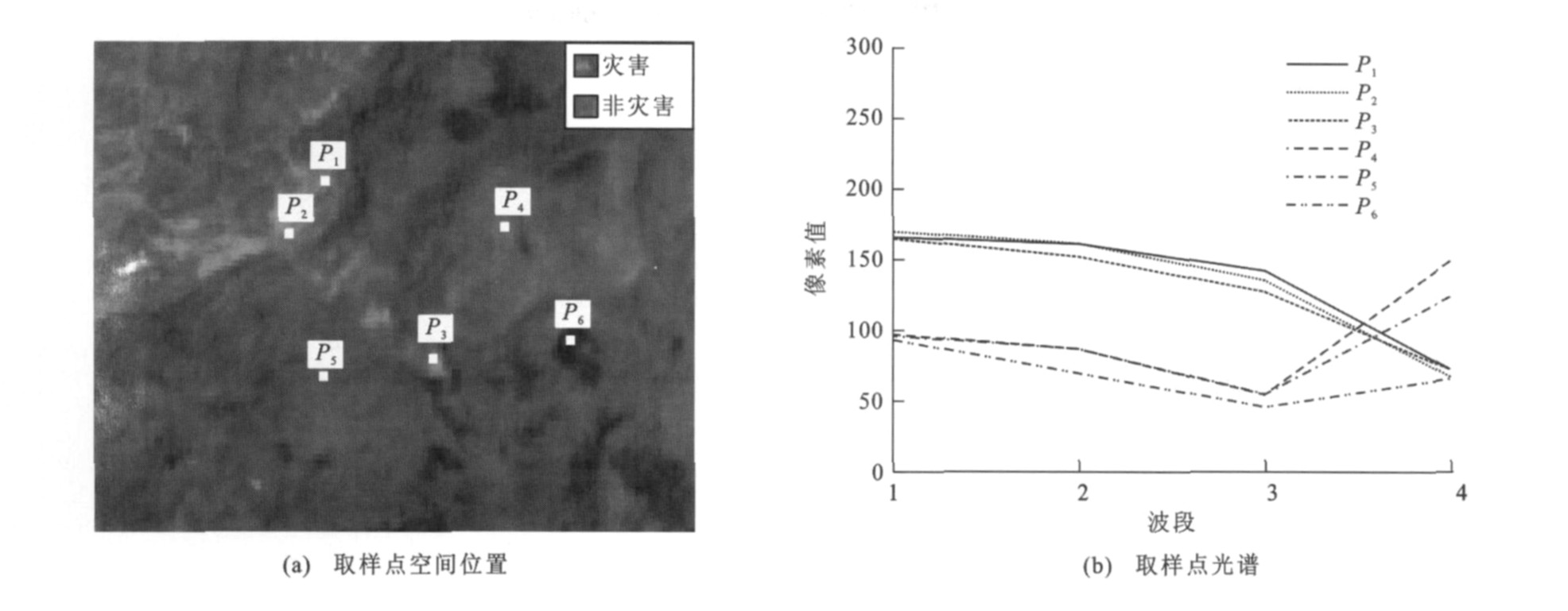
图 1 滑坡和泥石流灾害与周边光谱信息的对比
Figure 1. Comparison of spectrum information of landslide and mud-rock flow with neighboring regions' spectrum information

图 2 滑坡和泥石流在ALOS影像4个波段中的光谱信息对比
Figure 2. Comparison of spectrum information of landslide and mud-rock flow in ALOS four-band images

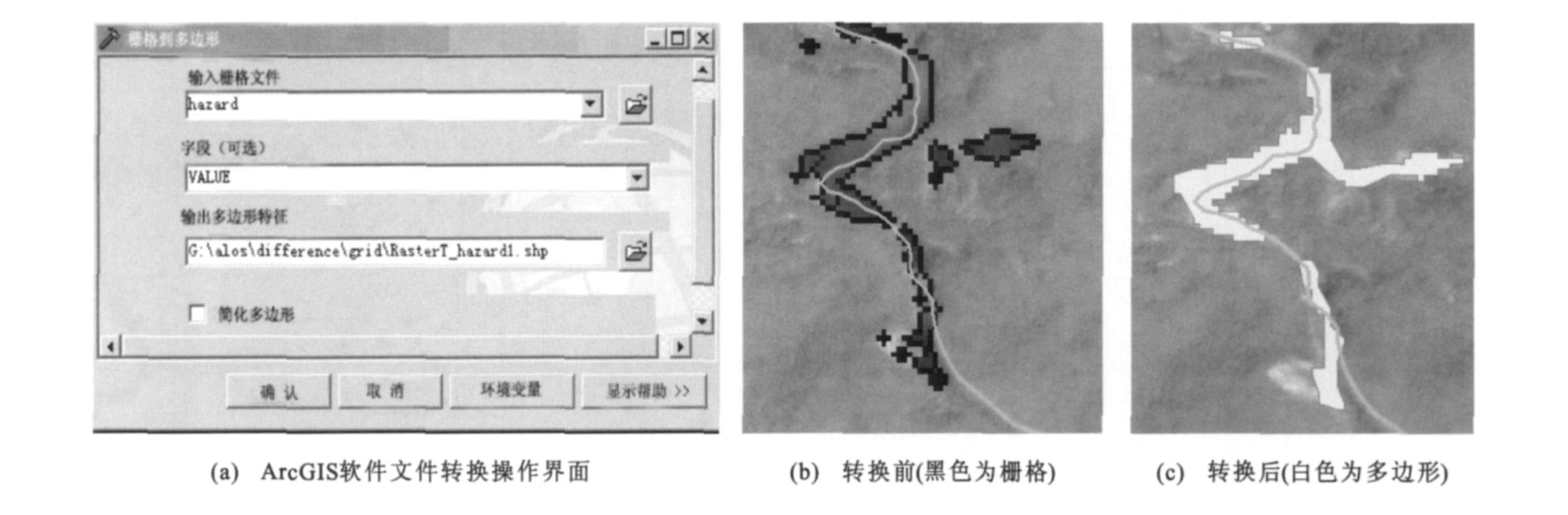
图 8 公路水毁遥感监测评估技术流程
Figure 8. Technical procedure of monitoring and evaluating highway water destruction
表 1 基于GIS的道路数据库结构
Table 1. Road database structure based on GIS
字段名 类型 长度 备注 ID Short Integer 6 编号 glmc Text 50 公路名称 glbh Text 8 公路编号 lmkd Float 6 路面宽度 ljkd Float 6 路基宽度 length Float 10 长度 gldj Text 10 公路等级(高速、一、二、三、四级、其他) glxz Text 10 公路性质(国、省、县、乡村) ljxz Text 20 路基性质(沙土路基与煤矸石路基) lmlx Text 20 路面类型(沥青混凝土、水泥混凝土……) bplx Text 30 边坡类型 fwnx Short Integer 3 服务年限 sjss Short Integer 3 设计时速 cds Short Integer 2 车道数 price Float 10 单位长度造价  下载: 导出CSV
-
[1] 沈波, 艾翠玲. 我国山区公路排水问题及水毁调查分析[J]. 公路交通科技, 2006, 23 (10): 5-9, 19. https://www.cnki.com.cn/Article/CJFDTOTAL-GLJK200610001.htmSHEN Bo, AI Cui-ling. Mountain area highway drainage and water damage survey and analysis[J]. Journal of Highway and Transportation Research and Development, 2006, 23 (10): 5-9, 19. (in Chinese) https://www.cnki.com.cn/Article/CJFDTOTAL-GLJK200610001.htm [2] 陈洪凯, 唐红梅, 吴承平, 等. 四川省公路水毁与地质环境的关系探讨[J]. 重庆交通学院学报, 1994, 13 (4): 24-33. https://www.cnki.com.cn/Article/CJFDTOTAL-CQJT404.003.htmCHEN Hong-kai, TANG Hong-mei, WU Cheng-ping, et al. Discussion on relationships between geological environments and waste-waterings of highway in Sichuan Area[J]. Journal of Chongqing Jiaotong Institute, 1994, 13 (4): 24-33. (in Chinese) https://www.cnki.com.cn/Article/CJFDTOTAL-CQJT404.003.htm [3] 黄志才, 吴国雄, 程尊兰. 川藏公路沿河路基水毁成因分析与工程防护[J]. 水土保持通报, 2003, 23 (4): 21-23. https://www.cnki.com.cn/Article/CJFDTOTAL-STTB200304006.htmHUANG Zhi-cai, WU Guo-xiong, CHENG Zun-lan. Research on causes and prevention methods of water damage to Sichuan-Tibet Highway[J]. Bulletin of Soil and Water Conservation, 2003, 23 (4): 21-23. (in Chinese) https://www.cnki.com.cn/Article/CJFDTOTAL-STTB200304006.htm [4] 高速, 方向池. 公路水毁的研究防治现状及问题[J]. 中国减灾, 1999, 9 (3): 39-42. doi: 10.3969/j.issn.1002-4549.1999.03.011GAO Su, FANG Xiang-chi. Current status and problem of the research, prevention and cure on highway water damage[J]. Disaster Reductionin China, 1999, 9 (3): 39-42. (in Chinese) doi: 10.3969/j.issn.1002-4549.1999.03.011 [5] CHI K H, PARK N W, LEE K. Identification of landslide area using remote sensing data and quantitative assessment of landslide hazard[C]∥IEEE. Geoscience and Remote Sensing Symposium. Washington DC: IEEE, 2002: 2856-2858. [6] 侯春红. 公路地质灾害调查中的遥感技术[J]. 中国减灾, 2007, 17 (3): 32-33. https://www.cnki.com.cn/Article/CJFDTOTAL-ZGJI200703022.htmHOU Chun-hong. Remote sensing technology in investigation in highway geological disaster[J]. Disaster Reduction in China, 2007, 17 (3): 32-33. (in Chinese) https://www.cnki.com.cn/Article/CJFDTOTAL-ZGJI200703022.htm [7] 喻林青, 鲁安新, 冉德甫, 等. 国道214线西藏境滑塌灾害遥感调查研究[J]. 遥感技术与应用, 2006, 21 (6): 517-520. https://www.cnki.com.cn/Article/CJFDTOTAL-YGJS200606007.htmYU Lin-qing, LU An-xin, RAN De-fu, et al. Investigation of landslides and rockfalls hazards using remote sensing on the Tibet part of national highway 214[J]. Remote Sensing Technology and Application, 2006, 21 (6): 517-520. (in Chinese) https://www.cnki.com.cn/Article/CJFDTOTAL-YGJS200606007.htm [8] 王丽红, 鲁安新, 贾志裕, 等. 川藏公路西藏境道路病害遥感调查研究[J]. 遥感技术与应用, 2006, 21 (6): 512-516. https://www.cnki.com.cn/Article/CJFDTOTAL-YGJS200606006.htmWANG Li-hong, LU An-xin, JIA Zhi-yu, et al. The disaster investigation using remote sensing on the Tibet part of Sichuan-Tibet Highway[J]. Remote Sensing Technology and Application, 2006, 21 (6): 512-516. (in Chinese) https://www.cnki.com.cn/Article/CJFDTOTAL-YGJS200606006.htm [9] 王治华. RS+GCPS获取滑坡基本信息[J]. 中国地质灾害与防治学报, 2004, 15 (1): 94-101. https://www.cnki.com.cn/Article/CJFDTOTAL-ZGDH202001024.htmWANG Zhi-hua. RS+GCPS select basic information of landslide[J]. The Chinese Journal of Geological Hazard and Control, 2004, 15 (1): 94-101. (in Chinese) https://www.cnki.com.cn/Article/CJFDTOTAL-ZGDH202001024.htm -


 点击查看大图

计量
- 文章访问数: 651
- HTML全文浏览量: 75
- PDF下载量: 444
- 被引次数: 0
