

-
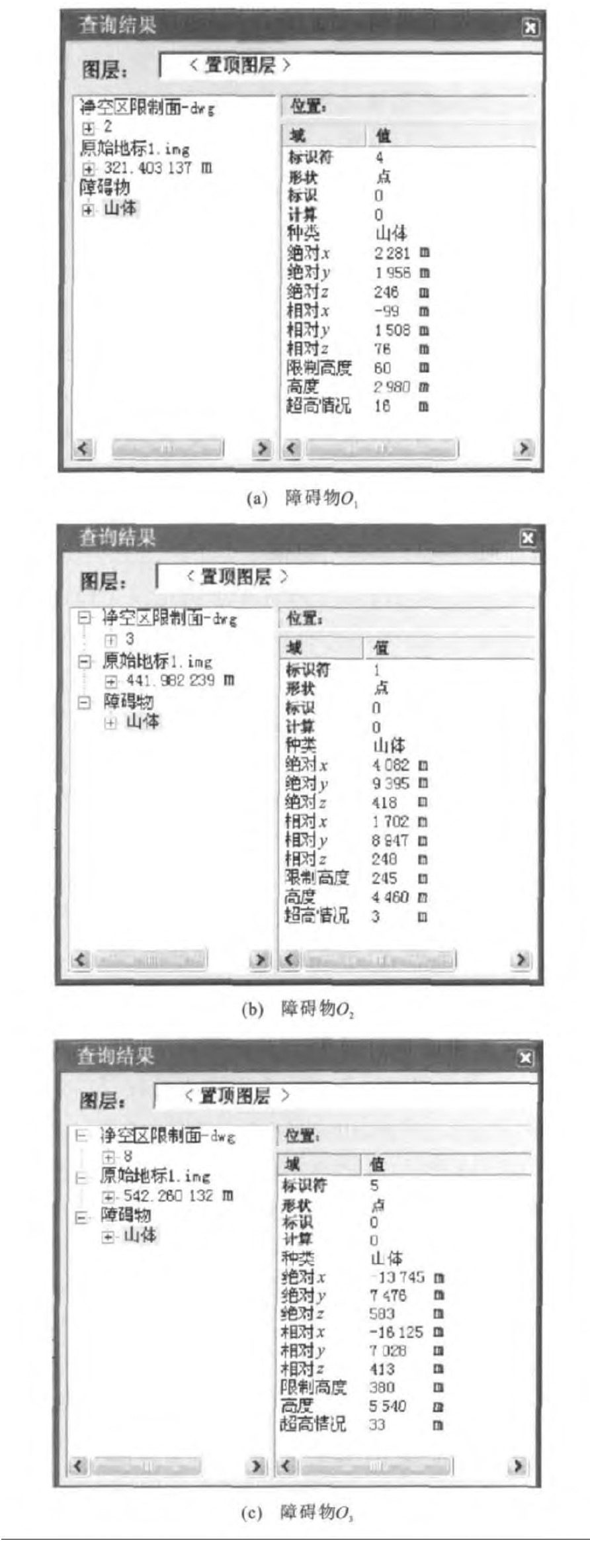
摘要: 对军用机场净空规格进行了分析, 建立了单跑道和平行双跑道机场净空区障碍物限制面的数学模型。在此数学模型的基础上, 使用ArcGIS系列软件建立平行双跑道机场净空限制面三角网高程模型, 并进行三维显示, 将数字高程模型与平行双跑道机场地形图相叠加, 对军用平行双跑道机场净空障碍物进行了评定。分析结果表明: 障碍物O1、O2、O3三点的实际高程分别为76、248、413 m, 净空限制面高度分别为60、245、380 m, 三点分别超高16、3、33 m。该评定方法可快速、准确地进行军用平行双跑道机场净空障碍物评定, 提高了评定效率。Abstract: Military airfield clearance specification was analyzed, the mathematical models of obstacle limit surfaces for single runway and parallel double-runway airfield clearances were built. Based on the models, the triangle mesh elevation model of parallel double-runway airfield clearance was built by using ArcGIS, and the 3D display result was got. Parallel double-runway airfield clearance obstacles were evaluated by superimposing digital elevation model (DEM) with corresponding topographic maps. Analysis result indicates that the actual elevations of obstacles O1, O2, O3 are respectively 76, 248, 413 m, the heights of clearance limit surfaces are respectively 60, 245, 380 m, and the exceeding heights are respectively 16, 3, 33 m. So the obstacles of parallel double-runway airfield clearance are evaluated by using the method quickly and exactly, and evaluation efficiency improves greatly.
-
Key words:
- parallel double-runway /
- military airfield /
- clearance /
- DEM /
- 3D visualization /
- GIS
-

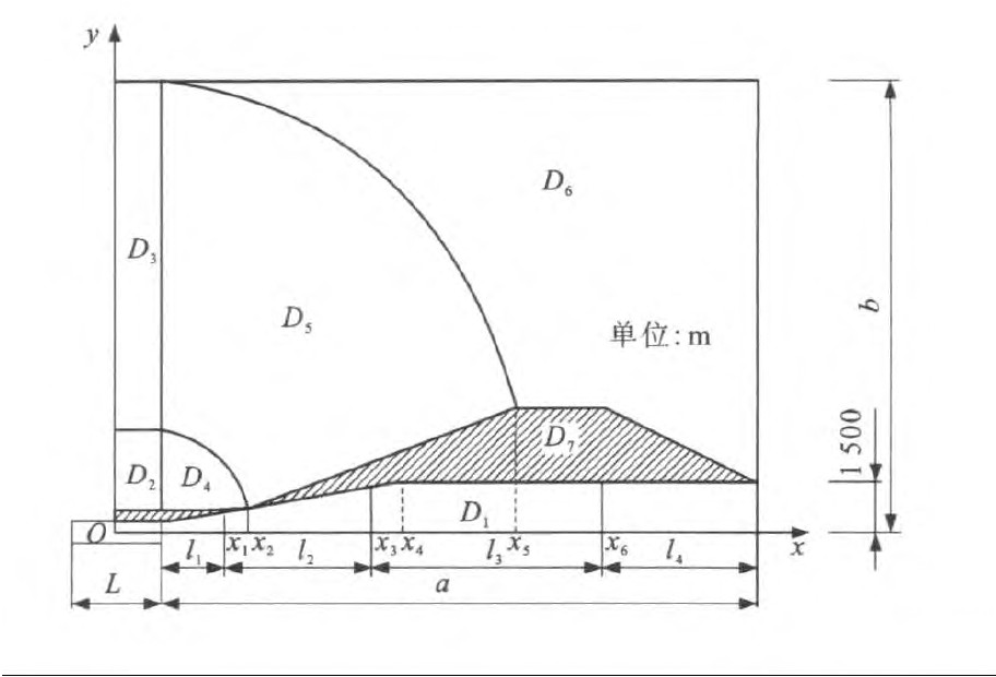
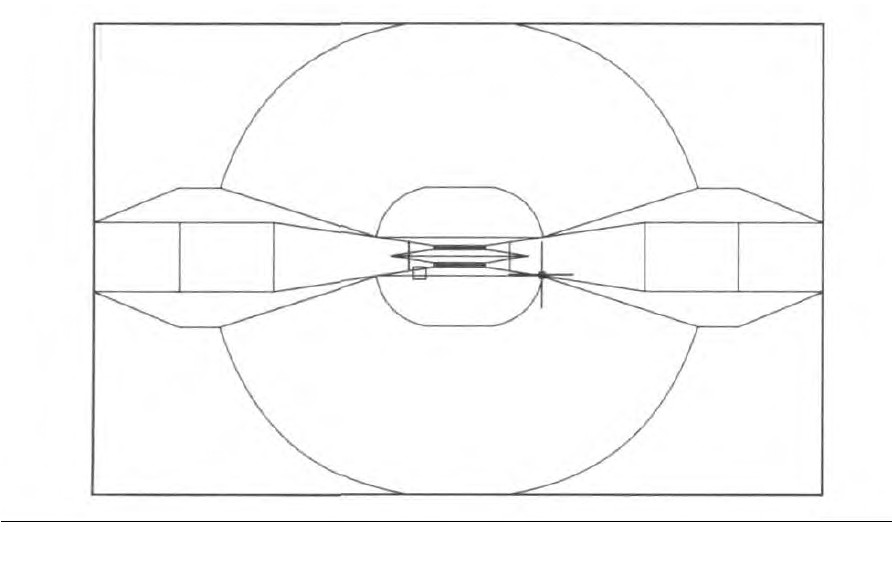
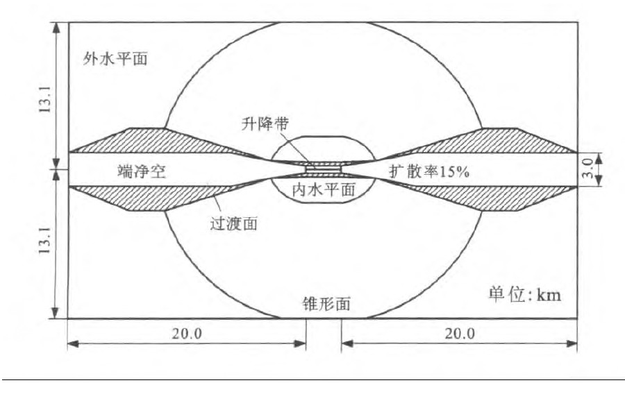
图 4 平行双跑道机场净空限制面平面
Figure 4. Plan of parallel double-runway airfield clearance limit surface

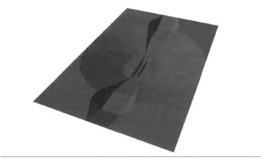
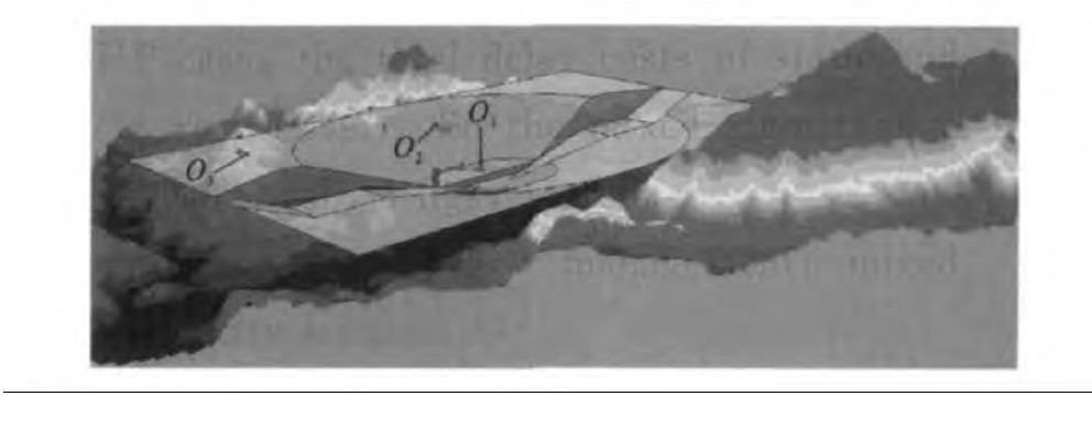
图 7 机场净空区障碍物限制面与相应地形
Figure 7. Airfield clearance obstacle limit surfaces and relevant topographic map
-
[1] 刘晓军, 种小雷, 蔡良才, 等. 机场净空区超高障碍物风险性分析[J]. 基建优化, 2007, 28 (6): 184-186. https://www.cnki.com.cn/Article/CJFDTOTAL-JJYH200706058.htmLIU Xiao-jun, CHONG Xiao-lei, CAI Liang-cai, et al. Analysis obstruction's risk to airplane in airfield clearance[J]. Optimization of Capital Construction, 2007, 28 (6): 184-186. (in Chinese) https://www.cnki.com.cn/Article/CJFDTOTAL-JJYH200706058.htm [2] 崔先国, 孙红丽. 构建机场净空区三维模型[J]. 矿山测量, 2008 (1): 19-20, 41. doi: 10.3969/j.issn.1001-358X.2008.01.005CUI Xian-guo, SUN Hong-li. Establishing 3D model of airfield clearance zone[J]. Mine Surveying, 2008 (1): 19-20, 41. (in Chinese) doi: 10.3969/j.issn.1001-358X.2008.01.005 [3] 戴晓爱, 杨武年, 夏涛, 等. 遥感图像三维可视化的实现及应用研究——以腾冲机场建设工程为例[J]. 地域研究与开发, 2008, 27 (4): 121-124. https://www.cnki.com.cn/Article/CJFDTOTAL-DYYY200804028.htmDAI Xiao-ai, YANG Wu-nian, XI A Tao, et al. Research on the realization and application of 3D visualization of remote sensing images—taking Tengchong Aerodrome as an example[J]. Areal Research and Development, 2008, 27 (4): 121-124. (in Chinese) https://www.cnki.com.cn/Article/CJFDTOTAL-DYYY200804028.htm [4] 蔡良才, 种小雷, 郑汝海, 等. 机场净空区障碍物限制面的确定分析[J]. 空军工程大学学报: 自然科学版. 2005, 6 (6): 1-3.CAI Liang-cai, CHONG Xiao-lei, ZHENG Ru-hai, et al. Analysis of confirmation to obstruction restrict in airfield clearance[J]. Journal of Air Force Engineering University: Natural Science Edition, 2005, 6 (6): 1-3. (in Chinese) [5] 马玉凡, 王卫安. 机场净空限制计算模型及可视化研究[J]. 测绘工程, 2008, 17 (1): 32-36. doi: 10.3969/j.issn.1006-7949.2008.01.009MA Yu-fan, WANG Wei-an. Research on the computing model of airport clearance limitation and its visualization[J]. Engineering of Surveying and Mapping, 2008, 17 (1): 32-36. (in Chinese) doi: 10.3969/j.issn.1006-7949.2008.01.009 [6] 蔡喜琴, 苗天宝, 曹建君, 等. 庆阳机场净空区超高障碍物三维分析研究[J]. 遥感技术与应用, 2004, 19 (5): 406-410. doi: 10.3969/j.issn.1004-0323.2004.05.022CAI Xi-qin, MI AO Tian-bao, CAO Jian-jun, et al. Threedimensional analysis of obstacle in the limited plane of Qingyang airport clearance[J]. Remote Sensing Technology and Appli-cation, 2004, 19 (5): 406-410. (in Chinese) doi: 10.3969/j.issn.1004-0323.2004.05.022 [7] 连健, 李小娟, 赵文吉, 等. 基于ArcScene的三维可视化系统设计与实现[J]. 地理空间信息, 2008, 6 (1): 83-86. https://www.cnki.com.cn/Article/CJFDTOTAL-DXKJ200801029.htmLIAN Jian, LI Xiao-juan, ZHAO Wen-ji, et al. Design and implementation of 3D modeling and visualization system based on ArcScene[J]. Geospatial Information, 2008, 6 (1): 83-86. (in Chinese) https://www.cnki.com.cn/Article/CJFDTOTAL-DXKJ200801029.htm [8] GJB 525A—2005, 军用永备机场场道工程战术技术标准[S].GJB 525A—2005, tactical and technical criteria for flying area engineering of the military long-term airfield[S]. (in Chinese) [9] 杨宏志, 韩跃杰, 李芬, 等. 基于GIS和遗传算法的公路智能选线[J]. 长安大学学报: 自然科学版, 2009, 29 (3): 48-53. https://www.cnki.com.cn/Article/CJFDTOTAL-XAGL200903010.htmYANG Hong-zhi, HAN Yue-jie, LI Fen, et al. Highway intelligent alignment selection based on GIS and genetic algorithms[J]. Journal of Chang'an University: Natural Science Edition, 2009, 29 (3): 48-53. (in Chinese) https://www.cnki.com.cn/Article/CJFDTOTAL-XAGL200903010.htm [10] 虎啸, 吴群琪, 陈雪, 等. 基于ArcGIS的基础路网规划方法[J]. 交通运输工程学报, 2009, 9 (5): 67-72. http://transport.chd.edu.cn/article/id/200905012HU Xiao, WU Qun-qi, CHEN Xue, et al. Planning method of basic road network based on ArcGIS[J]. Journal of Traffic and Transportation Eegineering, 2009, 9 (5): 67-72. (in Chinese) http://transport.chd.edu.cn/article/id/200905012 [11] 蔡博峰, 路瑞锁. 基于RS和GIS的公路生态影响研究[J]. 长安大学学报: 自然科学版, 2009, 29 (5): 54-58, 94. https://www.cnki.com.cn/Article/CJFDTOTAL-XAGL200905012.htmCAI Bo-feng, LU Rui-suo. Application of RS and GISto road ecological effect assessment[J]. Journal of Chang'an University: Natural Science Edition, 2009, 29 (5): 54-58, 94. (in Chinese) https://www.cnki.com.cn/Article/CJFDTOTAL-XAGL200905012.htm [12] 种小雷, 蔡良才, 杨锐. 基于GIS的机场净空评定方法[J]. 测绘通报, 2002 (11): 52-53, 63. https://www.cnki.com.cn/Article/CJFDTOTAL-CHTB200211021.htmCHONG Xiao-lei, CAI Liang-cai, YANG Rui. GIS-based airfield clearance assessing method[J]. Bulletin of Surveying and Mapping, 2002 (11): 52-53, 63. (in Chinese) https://www.cnki.com.cn/Article/CJFDTOTAL-CHTB200211021.htm [13] 王治, 蔡良才, 种小雷. 基于GIS的机场功能区规划用地适宜性评价[J]. 空军工程大学学报: 自然科学版, 2006, 7 (4): 23-25. https://www.cnki.com.cn/Article/CJFDTOTAL-KJGC200604007.htmWANG Zhi, CAI Liang-cai, CHONG Xiao-lei. Study of airport functional section suitability evaluation based on GIS[J]. Journal of Air Force Engineering University: Natural Science Edition, 2006, 7 (4): 23-25. (in Chinese) https://www.cnki.com.cn/Article/CJFDTOTAL-KJGC200604007.htm -

 下载:
下载:


 点击查看大图
图(8) / 表(2)
计量
- 文章访问数: 664
- HTML全文浏览量: 247
- PDF下载量: 438
- 被引次数: 0
