

Automatic detection method of roads from fuzzy aerial images
-
摘要: 为了在模糊航空图像中精确地检测道路, 通过分析图像中道路特性, 提出了一种道路自动检测方法。通过多尺度Retinex算法增强模糊图像, 用改进的Canny边缘检测算法检测图像中的主要路段, 使用交叉熵理论和贝叶斯决策理论自动获取梯度图像中的高低阈值, 从而将灰度图像转化为二值图像, 并将图像中所有线性目标进行骨架提取。根据线性目标的形状与尺寸参数进行噪声滤除, 并根据端点的方向与端点间的距离进行道路间隙缝合, 并结合边缘和原始图像信息调节和修正已检测出的道路。将道路自动检测方法与几种常用的图像分割算法进行比较, 包括大津阈值分割算法, Canny边缘检测算法与图论最小割算法, 并使用道路自动检测方法对模糊图像中的单条道路、交叉道路和多条道路进行检测。检测结果表明: 对模糊或光照不均的航空道路图像, Retinex算法增强图像后可以清晰显示主干道路, 而常规的图像分割算法无法将主干道提取出来, 使用改进的Canny边缘检测算法并附以图像后处理功能较好地提取主干道路。使用道路自动检测方法能够清晰地检测模糊航空图像中单条道路、交叉道路和多条道路, 与人工识别的效果接近。Abstract: In order to accurately detect the road from fuzzy aerial images, an automatic road detection method was proposed based on the characteristics of roads in images.The fuzzy images were enhanced by using multiple scale Retinex algorithm.The main road segments in images were detected by using improved Canny edge detection algorithm, and the high and low thresholds in gradient images were automatically obtained by using cross-entropy theory and Bayesian judgment theory, the gray image was transformed into the binary images, and the skeletons of linear target in the image were extracted.The noise was filtered based on the shape and size characteristics in the linear target, the gaps between segments were linked based on the curvature and the distances between segments, and the detected road was adjusted and modified by combing the edge and the original image information.The proposed automatic road detection method was compared with several widely used traditional algorithms, such as Otsu threshold segmentation algorithm, Canny edge detection algorithm, and graph theory based on the minimum segmentation algorithm.a single road, cross roads and several roads in fuzzy images were detected by using the proposed road detection method.Detection result indicates that as forfuzzy or uneven-illumination aerial road images, the trunk roads can be clearly displayed after enhancing images by Retinex algorithm, while the conventional image segmentation algorithm can not do.The trunk road can be well extracted by using the improved Canny edge detection algorithm with image post-processing function.In the detection of single road, cross roads and several roads in the fuzzy aerial images, the target roads can be clearly detected by using the proposed method.The effect of detection method is close to the result of artificial recognition.
-
Key words:
- image processing /
- road detection /
- fuzzy aerial image /
- multi-scale /
- Retinex algorithm /
- Canny edge detection algorithm /
- road shape
-

图 5 单条道路图像Canny边缘检测算法处理结果
Figure 5. Result of Canny edge detection algorithm for single road image

图 7 单条道路图像去除不规则形状目标结果
Figure 7. Result of irregular shape target removal for single road image

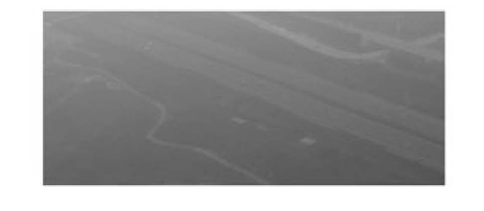
图 10 交叉道路图像Retinex算法处理结果
Figure 10. Result of Retinex algorithm for junction roads image

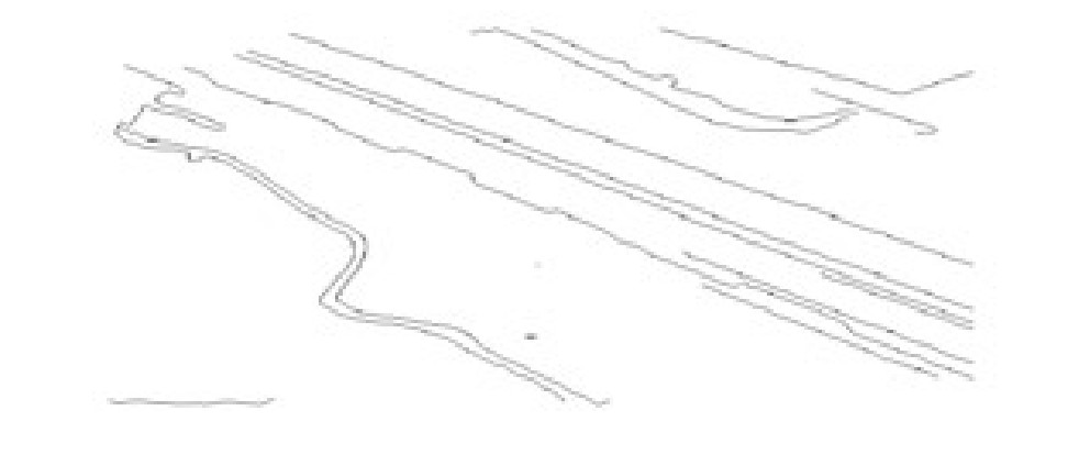
图 11 交叉道路图像Canny边缘检测算法处理结果
Figure 11. Result of Canny edge detection algorithm for junction roads image

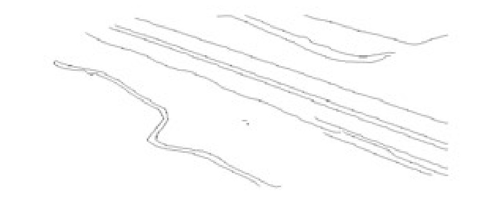
图 12 交叉道路图像缝合与去噪结果
Figure 12. Result of suture and de-noising for junction roads image

图 13 交叉道路图像去除不规则形状目标结果
Figure 13. Result of irregular shape target removal for junction roads image

图 16 多条道路图像Retinex算法处理结果
Figure 16. Result of Retinex algorithm for multiple roads image

图 17 多条道路图像Canny边缘检测算法处理结果
Figure 17. Result of Canny edge detection algorithm for multiple roads image

图 18 多条道路图像缝合与去噪结果
Figure 18. Result of suture and de-noising for multiple roads image

图 19 多条道路图像去除不规则形状目标结果
Figure 19. Result of irregular shape target removal for multiple roads image
-
[1] FISCHLER M A, TENENBAUM J M, WOLF H C. Detection of roads and linear structures in low-resolution aerial imagery using a multisource knowledge integration technique[J]. Computer Graphics and Image Processing, 1981, 15(3): 201-223. doi: 10.1016/0146-664X(81)90056-3 [2] 杨俊, 王润生. 遥感道路的场景感知与分类检测[J]. 计算机辅助设计与图形学学报, 2007, 19(3): 334-339. https://www.cnki.com.cn/Article/CJFDTOTAL-JSJF200703010.htmYANG Jun, WANG Run-sheng. Scene perception and classified detection for roads in remote sensing images[J]. Journal of Computer-Aided Design and Computer Graphics, 2007, 19(3): 334-339. (in Chinese). https://www.cnki.com.cn/Article/CJFDTOTAL-JSJF200703010.htm [3] CORD A, CHAMBON S. Automatic road defect detection by textural pattern recognition based on AdaBoost[J]. ComputerAided Civil and Infrastructure Engineering, 2012, 27(4): 244-259. doi: 10.1111/j.1467-8667.2011.00736.x [4] RAJESWARI M, GURUMURTHY K S, REDDY L P, et al. Automatic road extraction based on level set normalized cuts and mean shift methods[J]. International Journal of Computer Science Issues, 2011, 8(3): 250-257. [5] HILLEL A B, LERNER R, LEVI D, et al. Recent progress in road and lane detection: a survey[J]. Machine Vision and Applications, 2014, 25(3): 727-745. doi: 10.1007/s00138-011-0404-2 [6] ÜNSALAN C, SIRMACEK B. Road network detection using probabilistic and graph theoretical methods[J]. IEEE Transaction on Geoscience and Remote Sensing, 2012, 50(11): 4441-4453. doi: 10.1109/TGRS.2012.2190078 [7] HU Jiu-xiang, RAZDAN A, FEMIANI J C, et al. Road network extraction and intersection detection from aerial images by trackingroad footprints[J]. IEEE Transactions on Geoscience and Remote Sensing, 2007, 45(12): 4144-4157. doi: 10.1109/TGRS.2007.906107 [8] 罗庆洲, 尹球, 匡定波. 光谱与形状特征相结合的道路提取方法研究[J]. 遥感技术与应用, 2007, 22(2): 339-344. https://www.cnki.com.cn/Article/CJFDTOTAL-YGJS200703007.htmLUO Qing-zhou, YIN Qiu, KUANG Ding-bo. Research on extracting road based on its spectral feature and shape feature[J]. Remote Sensing Technology and Application, 2007, 22(2): 339-344. (in Chinese). https://www.cnki.com.cn/Article/CJFDTOTAL-YGJS200703007.htm [9] SALAH M B, MITICHE A, AYED I B. Multiregion image segmentation by parametric kernel graph cuts[J]. IEEE Transactions on Image Processing, 2011, 20(2): 545-557. doi: 10.1109/TIP.2010.2066982 [10] ZHANG Shao-yang, WANG Wei-xing, LIU Sheng, et al. Image enhancement on fractional differential for road traffic and aerial images under bad weather and complicated situations[J]. Transportation Letters: The International Journal of Transportation Research, 2014, 6(4): 197-205. [11] 王卫星, 于鑫, 赖均. 一种改进的分数阶微分掩模算子[J]. 模式识别与人工智能, 2010, 23(2): 171-177. https://www.cnki.com.cn/Article/CJFDTOTAL-MSSB201002007.htmWANG Wei-xing, YU Xin, LAI Jun. An improved fractional differential mask[J]. Pattern Recognition and Artificial Intelligence, 2010, 23(2): 171-177. (in Chinese). https://www.cnki.com.cn/Article/CJFDTOTAL-MSSB201002007.htm [12] MA Rong-gui, WANG Wei-xing, LIU Sheng. Extracting roads based on Retinex and improved Canny operator with shape criteria in vague and unevenly illuminated aerial images[J]. Journal of Applied Remote Sensing, 2012, 6(23): 1-14. [13] WANG Wei-xing, ZHAO Wei-sen, HUANG Ling-xiao, et al. Applications of terrestrial laser scanning for tunnels: a review[J]. Journal of Traffic and Transportation Engineering: English Edition, 2014, 1(5): 325-337. doi: 10.1016/S2095-7564(15)30279-8 [14] WANG Wei-xing. Image analysis of aggregates[J]. Computers and Geosciences, 1999, 25(1): 71-81. doi: 10.1016/S0098-3004(98)00109-5 [15] WANG Wei-xing. Colony image acquisition system and segmentation algorithms[J]. Optical Engineering, 2011, 50(12): 1-9. [16] ZHAO Xiang-mo, WANG Wei-xing, WANG Li-ping. Parameter optimal determination for Canny edge detection[J]. Imaging Science Journal, 2011, 59(9): 332-341. [17] WANG Wei-xing, BERGHOLM F, YANG B. Froth delineation based on image classification[J]. Minerals Engineering, 2003, 16(11): 1183-1192. [18] RAHMAN Z U, JOBSON D J, WOODELL G A. Investigating the relationship between image enhancement and image compression in the context of the multi-scale retinex[J]. Journal of Visual Communication and Image Representation, 2011, 22(3): 237-250. [19] KIMMELR, ELAD M, SHAKED D, et al. A variational framework for Retinex[J]. International Journal of Computer Vision, 2003, 52(1): 7-23. [20] WANG Wei-xing, LUO Dai-jian, LI Wei-sheng. Algorithm for automatic image registration on Harris-Laplace feature[J]. Journal of Applied Remote Sensing, 2009, 3(8): 1-13. [21] 雷小奇, 王卫星, 赖均. 一种基于形状特征进行高分辨率遥感影像道路提取方法[J]. 测绘学报, 2009, 38(5): 457-465. https://www.cnki.com.cn/Article/CJFDTOTAL-CHXB200905016.htmLEI Xiao-qi, WANG Wei-xing, LAI Jun. A method of road extraction from high-resolution remote sensing images based on shape features[J]. Acta Geodaetica et Cartographica Sinica, 2009, 38(5): 457-465. (in Chinese). https://www.cnki.com.cn/Article/CJFDTOTAL-CHXB200905016.htm -

 下载:
下载:


 点击查看大图

计量
- 文章访问数: 805
- HTML全文浏览量: 137
- PDF下载量: 907
- 被引次数: 0
