

Evaluation on snow calamity along Qinghai-Tibet Highway corridor based on multi-source remote sensing data
-
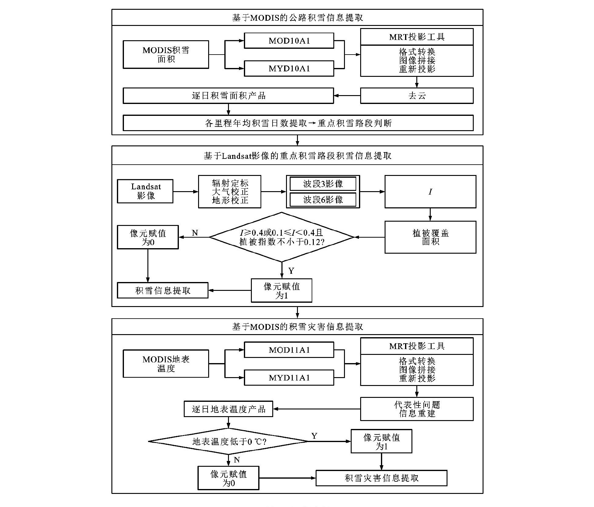
摘要: 利用多源遥感数据信息, 开展了青藏公路走廊所在区域的积雪空间分布特征调查, 对重点路段进行了积雪灾害评估。充分考虑了地形和山地积雪特征, 采用多种去云过程和步骤相结合, 完成逐日积雪云量消除。利用无云MODIS逐日积雪面积数据统计年均积雪日数, 在大尺度范围内提取公路积雪信息, 判断整个线路中重点积雪路段。利用Landsat影像的高空间分辨率特性, 采用归一化差值积雪指数阈值法识别重点积雪路段各里程处积雪和非积雪区域, 有效提取了公路重点积雪路段积雪空间分布信息, 更加精确地对公路积雪灾害进行监测和评估。基于影像时空信息对云覆盖像元下地表温度信息进行了重建, 并对代表性问题进行分析验证, 采用重建的MODIS逐日地表温度计算年均地表温度, 对青藏公路走廊沿线重点积雪路段的积雪灾害信息进行判断提取。分析结果表明: 评价方法可以有效地对青藏公路走廊沿线积雪分布进行监测与提取, 重点积雪区域主要分布在昆仑山、五道梁、风火山、唐古拉山, 其中部分路段积雪量较大且易发生道路结冰现象。Abstract: Based on the multi-source remote sensing data, the spatial distribution characteristic of the snow cover along the Qinghai-Tibet Highway corridor was surveyed, and the snow calamity was evaluated for key road sections. Terrain and mountain snow cover characteristics were fully considered, the cloud-removing of daily snow cover was finished by jointly using of types of cloud-removing processes and steps. The annual average snow cover days were statistically counted by the data of cloud-removed MODIS daily snow cover area. The highway snow cover information within a large scale was extracted and used to determine the key snow cover sections along the entire road. Taking the advantage of high spatial resolution of Landsat images, the snow area and snow-free area of key sections were identified by using normalized difference snow index threshold method, the spatial distribution information of snow cover of key sections along the highway was effectively extracted, which would contribute to more accurate observation and evaluation on highway snow calamity. Based on the temporal-spatial information of images, theground surface temperature information under cloud cover was rebuilt, and the representative questions were analyzed and verified. Using the reconstructed MODIS daily ground surface temperature, annual average ground surface temperature was computed, the snow calamity information in the key snow cover road sections along the Qinghai-Tibet Highway corridor were determined and extracted. Analysis result indicates that evaluation method is able to effectively monitor and extract the snow cover distribution along the Qinghai-Tibet Highway corridor, and the key snow cover regions are Kunlun Mountains, Wudaoliang, Fenghuo Mountain and Tanggula Mountains, part of road sections have large amount of snow accumulation and are subject to road icing.
-

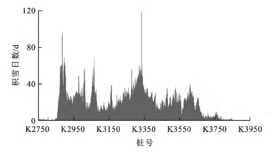
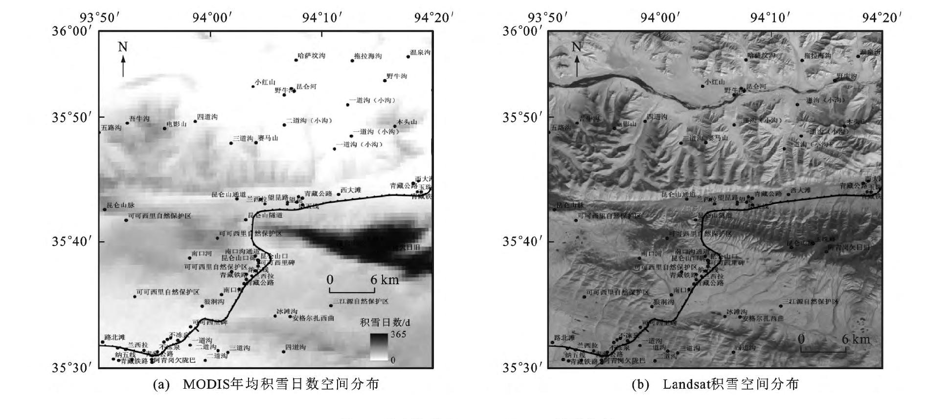
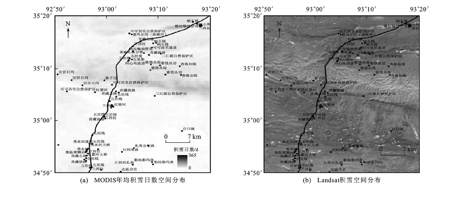
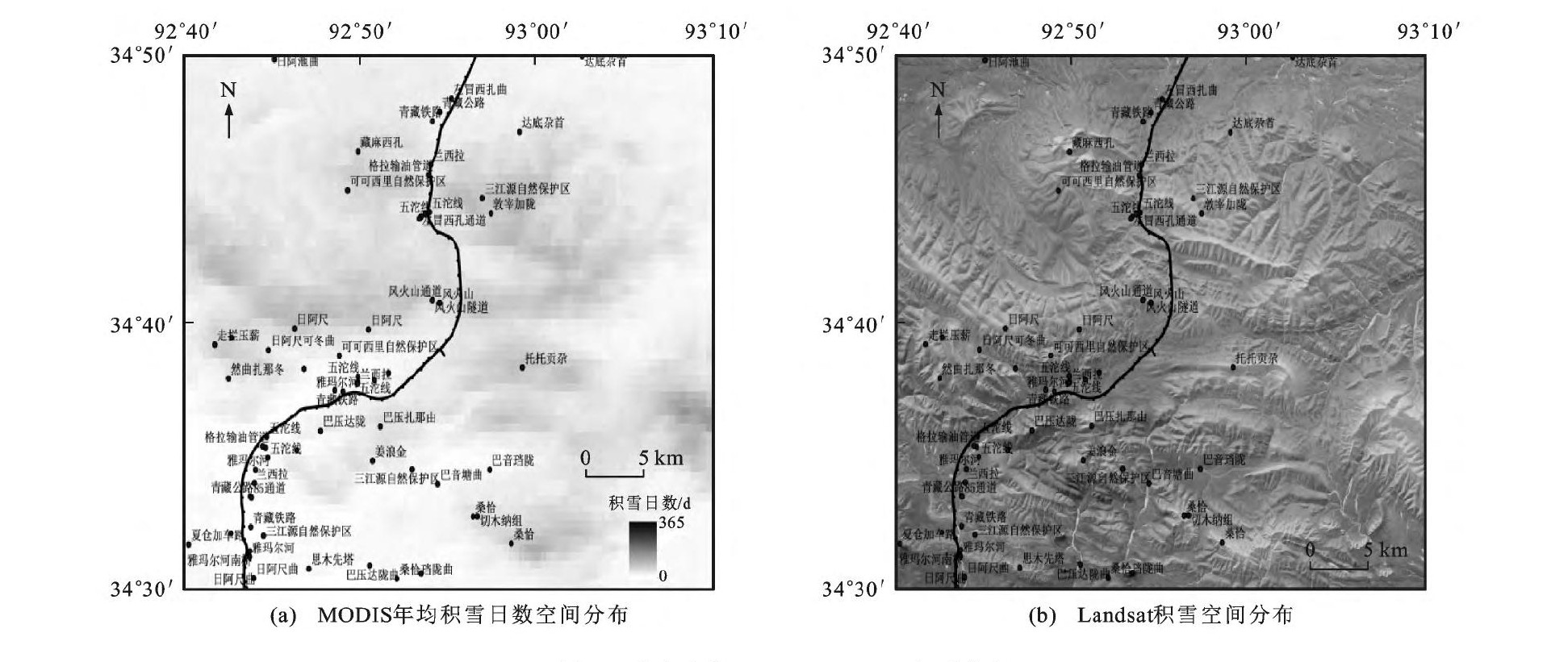
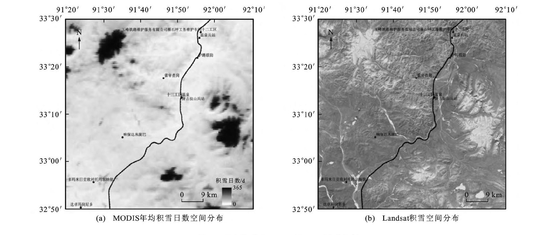
图 3 青藏高速公路沿线年均积雪日数
Figure 3. Annual average snow cover days along Qinghai-Tibet Highway

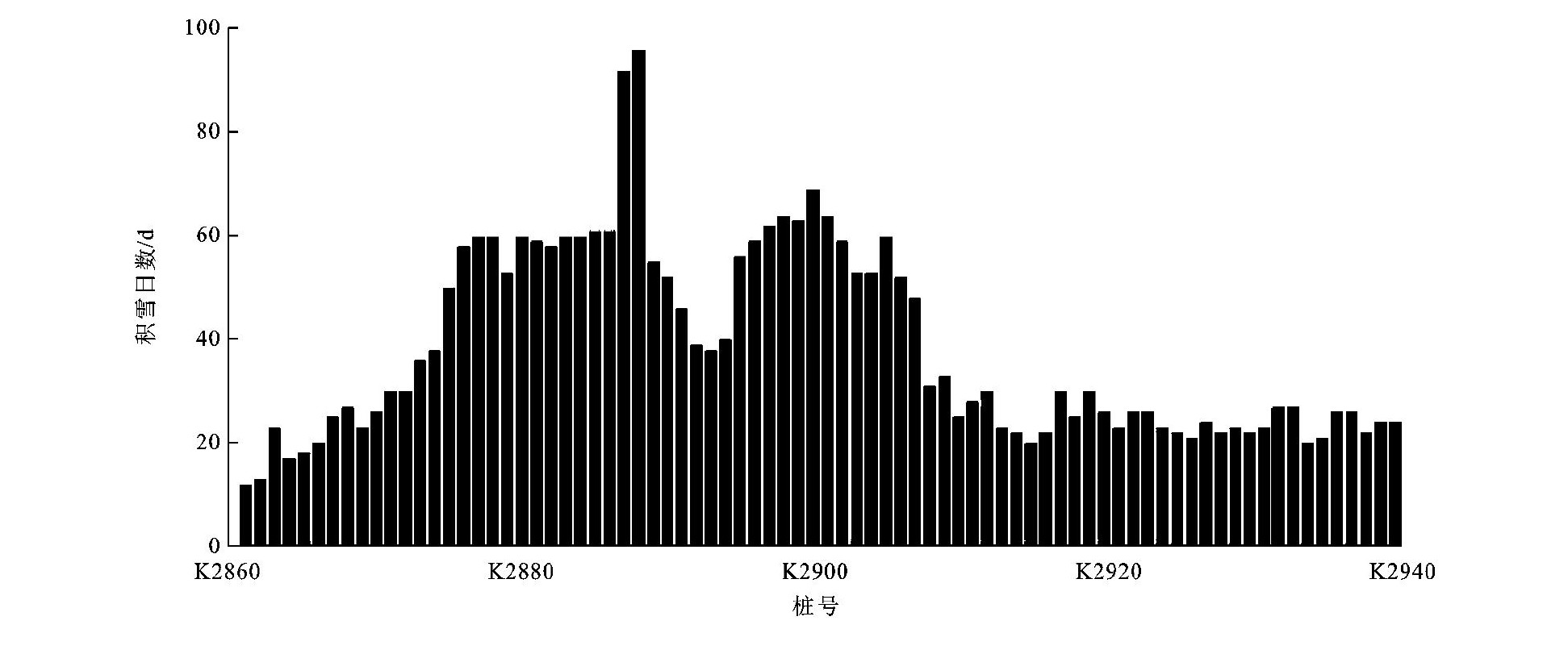
图 4 重点路段K2860~K2940积雪特征
Figure 4. Snow cover characteristics of key section K2860-K2940

图 5 重点路段K2950~K3020积雪特征
Figure 5. Snow cover characteristics of key section K2950-K3020

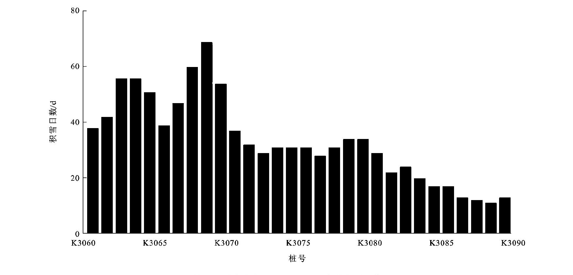
图 6 重点路段K3060~K3090积雪特征
Figure 6. Snow cover characteristics of key section K3060-K3090

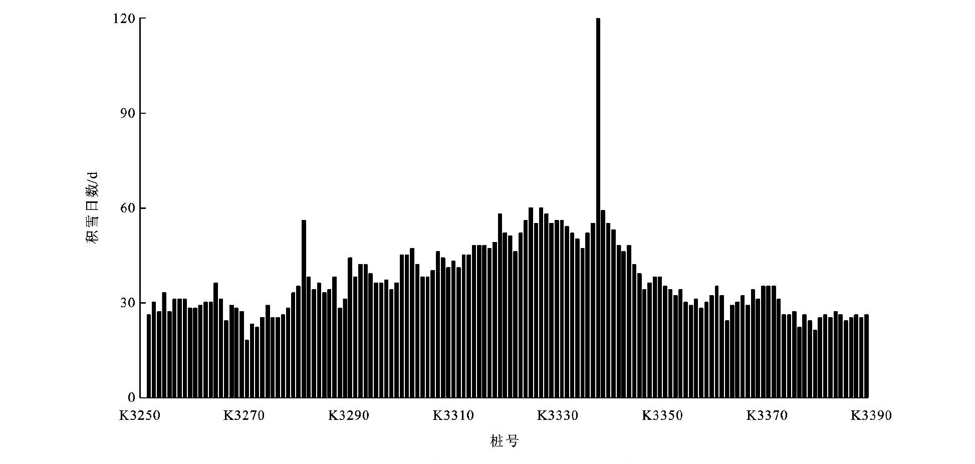
图 7 重点路段K3250~K3390积雪特征
Figure 7. Snow cover characteristics of key section K3250-K3390

图 8 重点路段K2860~K2940年均积雪日数
Figure 8. Annual average snow cover days of key section K2860-K2940

图 9 重点路段K2950~K3020年均积雪日数
Figure 9. Annual average snow cover days of key section K2950-K3020

图 10 重点路段K3060~K3090年均积雪日数
Figure 10. Annual average snow cover days of key section K3060-K3090

图 11 重点路段K3250~K3390年均积雪日数
Figure 11. Annual average snow cover days of key section K3250-K3390

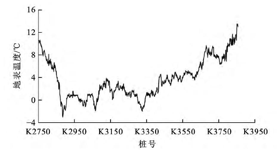
图 12 年均地表温度变化曲线
Figure 12. Variation curve of annual average ground surface temperatures
表 1 重建MODIS地表温度的验证
Table 1. Verification of reconstructed MODIS ground surface temperatures

 下载: 导出CSV
-
[1] 姚檀栋, 秦大河, 沈永平, 等. 青藏高原冰冻圈变化及其对区域水循环和生态条件的影响[J]. 自然杂志, 2013, 35(3): 179-185. https://www.cnki.com.cn/Article/CJFDTOTAL-ZRZZ201303004.htmYAO Tan-dong, QIN Da-he, SHEN Yong-ping, et al. Cryospheric changes and their impacts on regional water cycle and ecological conditions in the Qinghai-Tibetan Plateau[J]. Chinese Journal of Nature, 2013, 35(3): 179-185. (in Chinese). https://www.cnki.com.cn/Article/CJFDTOTAL-ZRZZ201303004.htm [2] 胡豪然, 梁玲. 近50年青藏高原东部冬季积雪的时空变化特征[J]. 地理学报, 2013, 68(11): 1493-1503. doi: 10.11821/dlxb201311005HU Hao-ran, LIANG Ling. Spatial and temporal variations of winter snow over east of Qinghai-Tibet Plateau in the last50years[J]. Acta Geographica Sinica, 2013, 68(11): 1493-1503. (in Chinese). doi: 10.11821/dlxb201311005 [3] LUCAS R M, HARRISON A R. Snow observation by satellite: a review[J]. Remote Sensing Reviews, 1990, 4(2): 285-348. doi: 10.1080/02757259009532109 [4] HALL D K, RIGGS G A, SALOMONSON V V, et al. MODIS snow-cover products[J]. Remote Sensing of Environment, 2002, 83(1): 181-194. [5] 冯学智, 鲁安新, 曾群柱. 中国主要牧区雪灾遥感监测评估模型研究[J]. 遥感学报, 1997, 1(2): 129-134. https://www.cnki.com.cn/Article/CJFDTOTAL-YGXB199702008.htmFENG Xue-zhi, LU An-xin, ZENG Qun-zhu. Study on snow disaster monitoring and assessment using remote sensing in the main pastoral areas of China[J]. Journal of Remote Sensing, 1997, 1(2): 129-134. (in Chinese). https://www.cnki.com.cn/Article/CJFDTOTAL-YGXB199702008.htm [6] 马丽娟, 秦大河, 卞林根, 等. 青藏高原积雪的脆弱性评估[J]. 气候变化研究进展, 2010, 6(5): 325-331. doi: 10.3969/j.issn.1673-1719.2010.05.003MA Li-juan, QIN Da-he, BIAN Lin-gen, et al. Assessment of snow cover vulnerability on the Qinghai-Tibetan Plateau[J]. Advances in Climate Change Research, 2010, 6(5): 325-331. (in Chinese). doi: 10.3969/j.issn.1673-1719.2010.05.003 [7] 闵文彬, 李宾. 近20年青藏高原气象卫星应用研究回顾与展望[J]. 高原山地气象研究, 2011, 31(3): 83-88. doi: 10.3969/j.issn.1674-2184.2011.03.017MIN Wen-bin, LI Bin. Review and prospect on the application of meteorological satellite data over Tibetan Plateau in the past 20 years[J]. Plateau and Mountain Meteorology Research, 2011, 31(3): 83-88. (in Chinese). doi: 10.3969/j.issn.1674-2184.2011.03.017 [8] HALL D K, RIGGS GA, FOSTER JL, et al. Development and evaluation of a cloud-gap-filled MODIS daily snow-cover product[J]. Remote Sensing of Environment, 2010, 114(3): 496-503. doi: 10.1016/j.rse.2009.10.007 [9] HALL D K, FOSTER J L, DIGIROLAMO N E, et al. Snow cover, snowmelt timing and stream power in the Wind River Range, Wyoming[J]. Geomorphology, 2012, 137(1): 87-93. doi: 10.1016/j.geomorph.2010.11.011 [10] 李震, 张文煜, 孙文新, 等. NOAA/AVHRR数据的雪盖信息提取与复合[J]. 遥感技术与应用, 1995, 10(4): 19-24. https://www.cnki.com.cn/Article/CJFDTOTAL-YGJS504.003.htmLI Zhen, ZHANG Wen-yu, SUN Wen-xin, et al. Extracting the information of snow-cover from NOAA/AVHRR data and overlaying with vector data[J]. Remote Sensing Technology and Application, 1995, 10(4): 19-24. (in Chinese). https://www.cnki.com.cn/Article/CJFDTOTAL-YGJS504.003.htm [11] 周咏梅, 贾生海, 刘萍. 利用NOAA-AVHRR资料估算积雪参量[J]. 气象科学, 2001, 21(1): 117-121. doi: 10.3969/j.issn.1009-0827.2001.01.015ZHOU Yong-mei, JIA Sheng-hai, LIU Ping. The method of snowcover parameters estimation using NOAA-AVHRR data[J]. Scientia Meteorologica Sinica, 2001, 21(1): 117-121. (in Chinese). doi: 10.3969/j.issn.1009-0827.2001.01.015 [12] 方墨人, 田庆久, 李英成, 等. 青藏高原MODIS图像冰雪信息挖掘与动态监测分析[J]. 地球信息科学, 2005, 7(4): 10-14. doi: 10.3969/j.issn.1560-8999.2005.04.004FANG Mo-ren, TIAN Qing-jiu, LI Ying-cheng, et al. Snow information extraction and dynamic changes analysis of Tibet based on MODIS data[J]. Geo-Information Science, 2005, 7(4): 10-14. (in Chinese). doi: 10.3969/j.issn.1560-8999.2005.04.004 [13] ARMSTRONG R L, BRODZIK M J. Hemispheric-scale comparison and evaluation of passive-microwave snow algorithms[J]. Annals of Glaciology, 2002, 34(1): 38-44. [14] 高峰, 李新, ARMSTRONG R L, 等. 被动微波遥感在青藏高原积雪业务监测中的初步应用[J]. 遥感技术与应用, 2003, 18(6): 360-363. doi: 10.3969/j.issn.1004-0323.2003.06.002GAO Feng, LI Xin, ARMSTRONG R L, et al. Preliminary application of passive microwave data to operational snow monitoring in Tibetan Plateau[J]. Remote Sensing Technology and Application, 2003, 18(6): 360-363. (in Chinese). doi: 10.3969/j.issn.1004-0323.2003.06.002 [15] 车涛, 李新, 高峰. 青藏高原积雪深度和雪水当量的被动微波遥感反演[J]. 冰川冻土, 2004, 26(3): 363-368. doi: 10.3969/j.issn.1000-0240.2004.03.019CHE Tao, LI Xin, GAO Feng. Estimation of snow water equivalent in the Tibetan Plateau using passive microwave romote sensing data(SSM/I)[J]. Journal of Glaciology and Geocryology, 2004, 26(3): 363-368. (in Chinese). doi: 10.3969/j.issn.1000-0240.2004.03.019 [16] 文军, DAI Mo, JEAN-PAUL D, 等. 利用MODIS和ASAR资料估算青藏高原念青唐古拉山脉地区冰雪范围及厚度[J]. 冰川冻土, 2006, 28(1): 54-61. doi: 10.3969/j.issn.1000-0240.2006.01.008WEN Jun, DAI Mo, JEAN-PAUL D, et al. Extent and depth of snow cover over the Nyainqêntanghla Range derived from MODIS and ASAR data[J]. Journal of Glaciology and Geocryology, 2006, 28(1): 54-61. (in Chinese). doi: 10.3969/j.issn.1000-0240.2006.01.008 [17] 王玮, 黄晓东, 吕志邦, 等. 基于MODIS和AMER-E资料的青藏高原牧区雪被制图研究[J]. 草业学报, 2013, 22(4): 227-238. https://www.cnki.com.cn/Article/CJFDTOTAL-CYXB201304029.htmWANG Wei, HUANG Xiao-dong, LU Zhi-bang, et al. A study on snow mapping in the Tibetan Plateau based on MODIS and AMSR-E data[J]. Acta Prataculturae Sinica, 2013, 22(4): 227-238. (in Chinese). https://www.cnki.com.cn/Article/CJFDTOTAL-CYXB201304029.htm [18] WANG Xian-wei, XIE Hong-jie, LIANG Tian-gang, et al. Comparison and validation of MODIS standard and new combination of Terra and Aqua snow cover products in northern Xinjiang, China[J]. Hydrological Processes, 2009, 23(3): 419-429. doi: 10.1002/hyp.7151 [19] ARSENAULT K R, HOUSER P R, DE LANNOY G J M. Evaluation of the MODIS snow cover fraction product[J]. Hydrological Processes, 2014, 28(3): 980-998. doi: 10.1002/hyp.9636 [20] 张颖, 黄晓东, 王玮, 等. MODIS逐日积雪覆盖率产品验证及算法重建[J]. 干旱区研究, 2013, 30(5): 808-814. https://www.cnki.com.cn/Article/CJFDTOTAL-GHQJ201305006.htmZHANG Ying, HUANG Xiao-dong, WANG Wei, et al. Validation and algorithm redevelopment of MODIS daily fractional snow cover products[J]. Arid Zone Research, 2013, 30(5): 808-814. (in Chinese). https://www.cnki.com.cn/Article/CJFDTOTAL-GHQJ201305006.htm [21] GARRATT J R. Observed screen(air)and GCM surface/screen temperatures: implications for outgoing longwave fluxes at the surface[J]. Journal of Climate, 1995, 8(5): 1360-1368. doi: 10.1175/1520-0442(1995)008<1360:OSAGST>2.0.CO;2 [22] 王之夏, 南卓铜, 赵林. MODIS地表温度产品在青藏高原冻土模拟中的适用性评价[J]. 冰川冻土, 2011, 33(1): 132-143. https://www.cnki.com.cn/Article/CJFDTOTAL-BCDT201101019.htmWANG Zhi-xia, NAN Zhuo-tong, ZHAO Lin. The applicability of MODIS land surface temperature products to simulating the permafrost distribution over the Tibetan Plateau[J]. Journal of Glaciology and Geocryology, 2011, 33(1): 132-143. (in Chinese). https://www.cnki.com.cn/Article/CJFDTOTAL-BCDT201101019.htm [23] NETELER M. Estimating daily land surface temperatures in mountainous environments by reconstructed MODIS LST data[J]. Remote Sensing, 2010, 2(1): 333-351. doi: 10.3390/rs1020333 [24] RAN You-hua, LI Xin, JIN Rui, et al. Remote sensing of the mean annual surface temperature and surface frost number for mapping permafrost in China[J]. Arctic Antarctic and Alpine Research, 2015, 47(2): 255-265. doi: 10.1657/AAAR00C-13-306 [25] YU Wen-ping, MA Ming-guo, WANG Xu-feng, et al. Estimating the land-surface temperature of pixels covered by clouds in MODIS products[J]. Journal of Applied Remote Sensing, 2014, 8(1): 1-14. [26] 柯灵红, 王正兴, 宋春桥, 等. 青藏高原东北部MODIS地表温度重建及其与气温对比分析[J]. 高原气象, 2011, 30(2): 277-287. https://www.cnki.com.cn/Article/CJFDTOTAL-GYQX201102003.htmKE Ling-hong, WANG Zheng-xing, SONG Chun-qiao, et al. Reconstruction of MODIS land surface temperature in northeast Qinghai-Xizang Plateau and its comparison with air temperature[J]. Plateau Meteorology, 2011, 30(2): 277-287. (in Chinese). https://www.cnki.com.cn/Article/CJFDTOTAL-GYQX201102003.htm [27] LIU Xiao-dong, YIN Zhi-zhong, SHAO Xue-mei, et al. Temporal trends and variability of daily maximum and minimum, extreme temperature events, and growing season length over the eastern and central Tibetan Plateau during1961-2003[J]. Journal of Geophysical Research: Atmospheres, 2006, 111(D19): 1-19. [28] 姜高珍, 韩冰, 高应波, 等. Landsat系列卫星对地观测40年回顾及LDCM前瞻[J]. 遥感学报, 2013, 17(5): 1033-1048. https://www.cnki.com.cn/Article/CJFDTOTAL-YGXB201305001.htmJIANG Gao-zhen, HAN Bing, GAO Ying-bo, et al. Review of 40-year earth observation with Landsat series and prospects of LDCM[J]. Journal of Remote Sensing, 2013, 17(5): 1033-1048. (in Chinese). https://www.cnki.com.cn/Article/CJFDTOTAL-YGXB201305001.htm [29] 徐涵秋, 唐菲. 新一代Landsat系列卫星: Landsat8遥感影像新增特征及其生态环境意义[J]. 生态学报, 2013, 33(11): 3249-3257. https://www.cnki.com.cn/Article/CJFDTOTAL-STXB201311002.htmXU Han-qiu, TANG Fei. Analysis of new characteristics of the first Landsat 8 image and their eco-environmental significance[J]. Acta Ecological Sinica, 2013, 33(11): 3249-3257. (in Chinese). https://www.cnki.com.cn/Article/CJFDTOTAL-STXB201311002.htm [30] HALL D K, RIGGS G A, SALOMONSON V V. Development of methods for mapping global snow cover using moderate resolution imaging spectroradiometer data[J]. Remote Sensing of Environment, 1995, 54(2): 127-140. doi: 10.1016/0034-4257(95)00137-P [31] 赵军, 陈恺悦, 师银芳. 提高森林覆盖区积雪提取精度的方法研究——以玛纳斯河流域为例[J]. 遥感技术与应用, 2015, 30(6): 1051-1058. https://www.cnki.com.cn/Article/CJFDTOTAL-YGJS201506003.htmZHAO Jun, CHEN Kai-yue, SHI Yin-fang. Methods research to improve the extraction accuracy of snow under forest cover—a case study of Manas River basin[J]. Remote Sensing Technology and Application, 2015, 30(6): 1051-1058. (in Chinese). https://www.cnki.com.cn/Article/CJFDTOTAL-YGJS201506003.htm -


 点击查看大图
计量
- 文章访问数: 680
- HTML全文浏览量: 143
- PDF下载量: 457
- 被引次数: 0
