

A fast detection method of airport runway area based on region segmentation and Wishart classifier
-
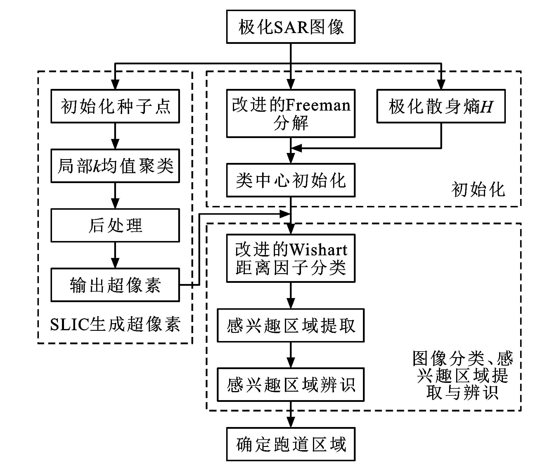
摘要: 提出了一种结合区域分割和Wishart分类器的极化合成孔径雷达图像机场跑道区域快速检测方法; 利用简单线性迭代聚类算法分割极化合成孔径雷达图像, 并将分割得到的超像素作为后续分类处理的基本单元; 采用一种优化后的距离度量方式给超像素分配类别标签, 解决了传统Wishart距离度量因子冗余运算量大的问题; 分析了机场跑道区域像素的极化散射特性, 利用机场跑道区域的弱散射特性从分类结果中提取感兴趣区域; 利用机场跑道的结构特征筛选辨识感兴趣区域, 进而确定机场跑道区域的准确位置; 利用极化合成孔径雷达实测数据测试了算法的有效性, 并与传统基于像素的检测结果进行对比。试验结果表明: 该算法在复杂大场景下能够快速有效检测出机场跑道区域, 检测出的跑道轮廓清晰, 结构比较完整; 采用简单线性迭代聚类算法预处理图像极大地降低了后续处理的复杂性; 针对墨西哥湾试验数据, Wishart分类器处理单元个数分别是Freeman+Wishart算法和FCM+Wishart算法的1.0%和2.4%, 整个检测过程耗时分别为Freeman+Wishart算法和FCM+Wishart算法的9.9%和27.1%;针对大岛试验数据, Wishart分类器处理单元个数分别是Freeman+Wishart算法和FCM+Wishart算法的1.0%和2.6%, 整个检测过程耗时分别为Freeman+Wishart算法和FCM+Wishart算法的14.0%和31.8%。可见, 所提检测方法的实时性能优于基于像素的检测方法。Abstract: A fast detection method of airport runway area using polarimetric synthetic aperture radar images was proposed based on region segmentation and Wishart classifier. A simple liner iterative clustering algorithm was utilized to partition polarimetric synthetic aperture radar image into many super-pixels, and these super-pixels were regarded as basic units for subsequent classification processing. An optimized distance measurement method was adopted to assign appropriate category labels for the super-pixels, greatly solving the problem of large redundant computation of traditional Wishart distance measurement factor. The polarization scattering characteristics of the pixels in airport runway area were analyzed, and the interest regions were extracted from the classification results using the weak scattering characteristic of airport runway area. The structural characteristics of airport runway were used to select and identify the extracted interest regions, thereby the accurate location of airport runway region was determined. The validity of the proposed algorithm was tested by the measured data from polarimetric synthetic aperture radar, and the detection results were compared with the traditional pixel-based detection results. Experimental result shows that in the large complicated scenes, the algorithm can detect the runway area fast and effectively, and the detected runway has clear outline and relatively complete structure. Using the simple linear iterative clustering algorithm to preprocess the images reduces the complexity of subsequent processing significantly. Based on the experimental data in the Gulf of Mexico, the processing unit number of Wishart classifier is only 1.0% and 2.4% of the numbers of Freeman+Wishart algorithm and FCM+Wishart algorithm, respectively, and the whole detection time is 9.9% and 27.1% of those of Freeman+Wishart algorithm and FCM+Wishart algorithm, respectively. Based on the experimental data in the Big Island, the processing unit number of Wishart classifier is only 1.0% and 2.6% of those of Freeman+Wishart algorithm and FCM+Wishart algorithm, respectively, and the whole detection time is 14.0% and 31.8% of those of Freeman+Wishart algorithm and FCM+Wishart algorithm, respectively. Thus, the real-time performance of the proposed detection method is superior to that of the pixel-based detection method.
-

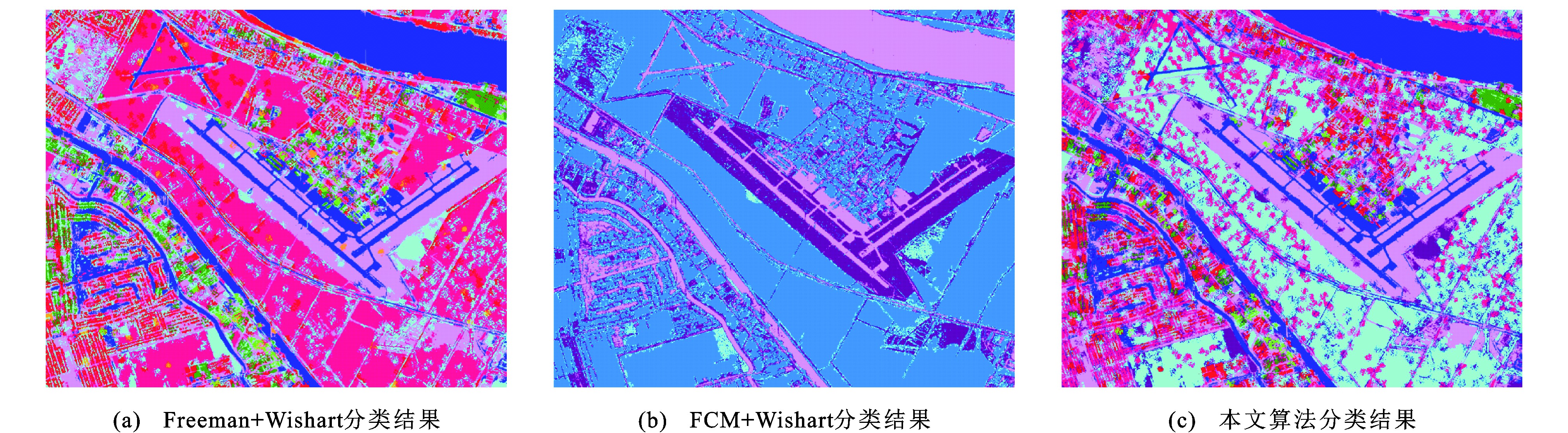
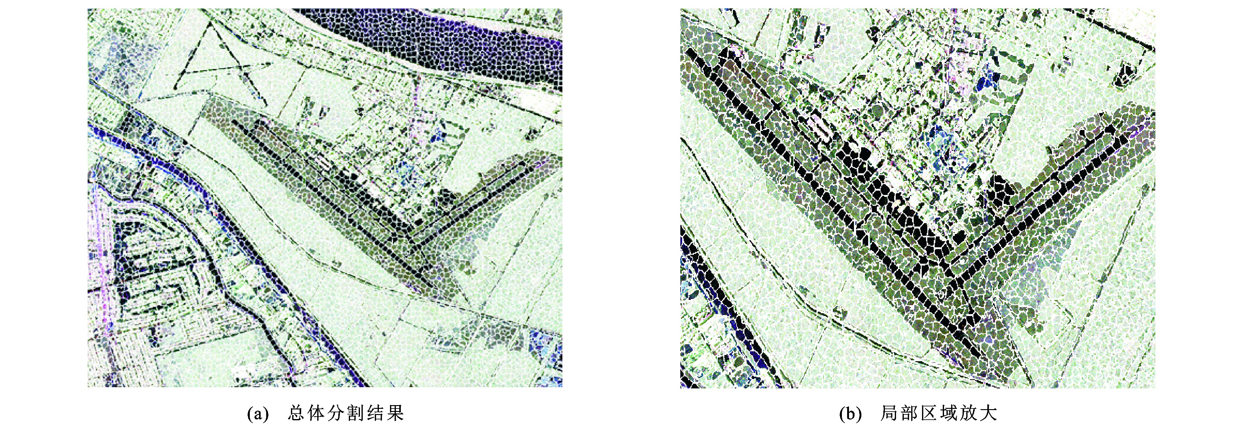
图 5 墨西哥湾无监督方法分类结果
Figure 5. Classification results of the Gulf of Mexico from unsupervised methods

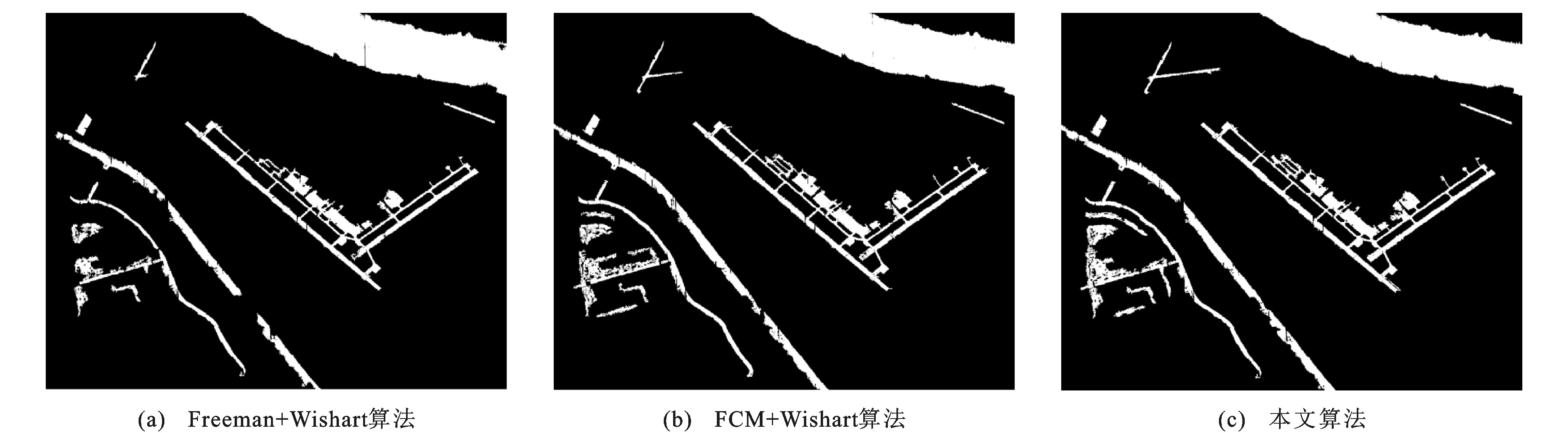
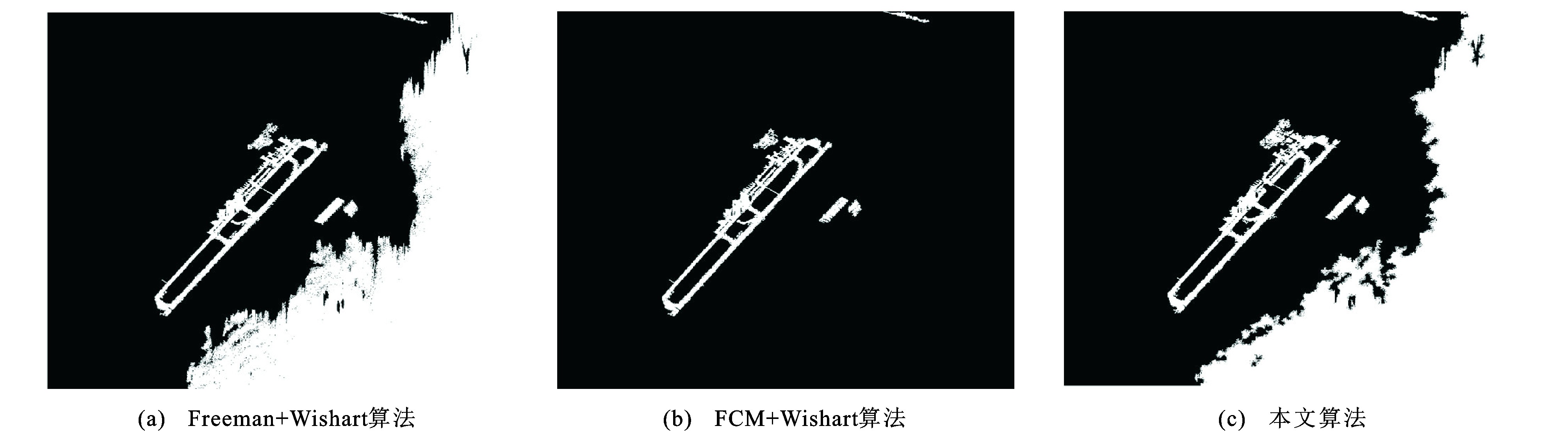
图 7 墨西哥湾不同算法检测结果对比
Figure 7. Detection results comparison of the Gulf of Mexico from different methods

图 10 大岛无监督方法分类结果
Figure 10. Classification results of the Big Island from unsupervised methods

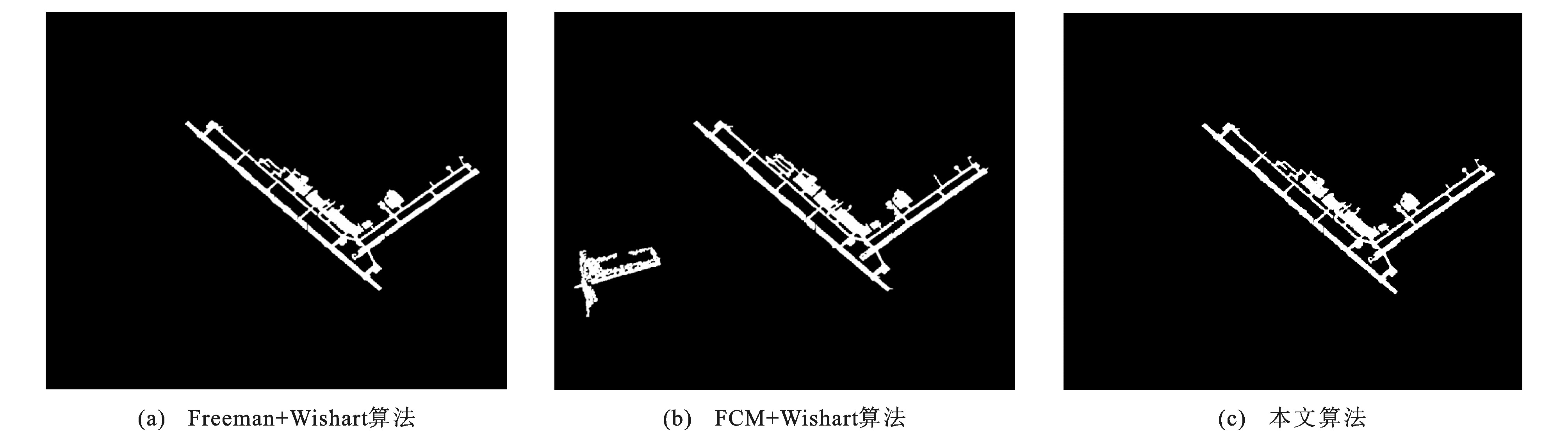
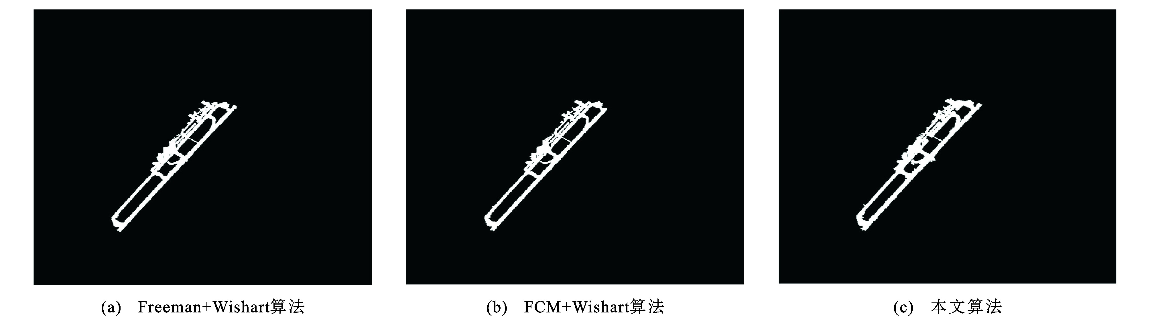
图 12 大岛不同算法检测结果对比
Figure 12. Detection results comparison of the Big Island from different methods
表 1 低熵类地物散射类别及其判决条件
Table 1. Scattering categories of ground objects with low entropy and their decision conditions
类别标号 判决条件 散射类别 1 Ps > Pd, Ps > Pv 表面散射 2 Pd > Ps, Pd > Pv 偶次散射 3 Pv > Ps, Pv > Pd 体散射  下载: 导出CSV
表 2 中熵类地物散射类别及其判决条件
Table 2. Scattering categories of ground objects with middle entropy and their decision conditions
类别标号 判决条件 散射类别 4 Ps > Pd > Pv 表面-偶次散射 5 Ps > Pv > Pd 表面-体散射 6 Pd > Ps > Pv 偶次-表面散射 7 Pd > Pv > Ps 偶次-体散射 8 Pv > Ps > Pd 体-表面散射 9 Pv > Pd > Ps 体-偶次散射
下载: 导出CSV
表 3 高熵类地物散射类别及其判决条件
Table 3. Scattering category of ground object with high entropy and its decision condition
类别标号 判决条件 散射类别 10 不做处理 归为一类
下载: 导出CSV
表 4 墨西哥湾不同算法运行效率
Table 4. Operation efficiencies of different algorithms of the Gulf of Mexico
算法 FCM算法处理像素数量 Wishart分类器处理像素数量 运行时间/s Freeman+Wishart算法 800 000 2 898.75 FCM+Wishart算法 800 000 329 983 1 058.80 本文算法 8 000 286.29
下载: 导出CSV
表 5 大岛不同算法运行效率
Table 5. Operation efficiencies of the Big Island from different algorithms
算法 FCM算法处理像素数量 Wishart分类器处理像素数量 运行时间/s Freeman+Wishart 810 000 2 955.76 FCM+Wishart 810 000 314 724 1 297.99 本文算法 8 100 412.72
下载: 导出CSV
表 6 其他场景检测统计结果
Table 6. Statistical results of other scenes
试验机场个数 检测出机场场景的个数 漏检机场场景个数 存在虚警场景个数 12 12 0 2
下载: 导出CSV
-
[1] LYU Wen-tao, DAI Kai-yan, WU Long, et al. Runway detection in SAR images based on fusion sparse representation and semantic spatial matching[J]. IEEE Access, 2018, 6: 27984-27992. doi: 10.1109/ACCESS.2018.2839025 [2] LIU Neng-yuan, CAO Zong-jie, CUI Zong-yong, et al. Multi-layer abstraction saliency for airport detection in SAR images[J]. IEEE Transactions on Geoscience and Remote Sensing, 2019, 57(12): 9820-9831. doi: 10.1109/TGRS.2019.2929598 [3] 艾淑芳, 闫钧华, 李大雷, 等. 遥感图像中的机场跑道检测算法[J]. 电光与控制, 2017, 24(2): 43-46. https://www.cnki.com.cn/Article/CJFDTOTAL-DGKQ201702009.htmAI Shu-fang, YAN Jun-hua, LI Da-lei, et al. An algorithm for detecting the airport runway in remote sensing image[J]. Electronics Optics and Control, 2019, 24(2): 43-46. (in Chinese). https://www.cnki.com.cn/Article/CJFDTOTAL-DGKQ201702009.htm [4] BUDAK Ü, HALICI U, ŞENGÜR A, et al. Efficient airport detection using line segment detector and fisher vector representation[J]. IEEE Geoscience and Remote Sensing Letters, 2016, 13(8): 1079-1083. doi: 10.1109/LGRS.2016.2565706 [5] LIU Neng-yuan, CUI Zong-yong, CAO Zong-jie, et al. Airport detection in large-scale SAR images via line segment grouping and saliency analysis[J]. IEEE Geoscience and Remote Sensing Letters, 2018, 15(3): 434-438. doi: 10.1109/LGRS.2018.2792421 [6] CHEN Fen, REN Rui-long, DE VOORDE T V, et al. Fast automatic airport detection in remote sensing images using convolutional neural networks[J]. Remote Sensing, 2018, 10(3): 1-20. [7] ZHANG Peng, NIU Xin, DOU Yong, et al. Airport detection on optical satellite images using deep convolutional neural networks[J]. IEEE Geoscience and Remote Sensing Letters, 2017, 14(8): 1183-1187. doi: 10.1109/LGRS.2017.2673118 [8] XU Yue-lei, ZHU Ming-ming, LI Shuai, et al. End-to-end airport detection in remote sensing images combining cascade region proposal networks and multi-threshold detection networks[J]. Remote Sensing, 2018, 10(10): 1-17. [9] ZHU Dan, WANG Bin, ZHANG Li-ming. Airport target detection in remote sensing images: a new method based on two-way saliency[J]. IEEE Geoscience and Remote Sensing Letters, 2015, 12(5): 1096-1100. doi: 10.1109/LGRS.2014.2384051 [10] TANG Ge-fu, XIAO Zhi-feng, LIU Qing, et al. A novel airport detection method via line segment classification and texture classification[J]. IEEE Geoscience and Remote Sensing Letters, 2015, 12(12): 2408-2412. doi: 10.1109/LGRS.2015.2479681 [11] ZHANG Zhe, ZOU Can, HAN Ping, et al. A runway detection method based on classification using optimized polarimetric features and HOG features for PolSAR images[J]. IEEE Access, 2020, 8: 49160-49168. doi: 10.1109/ACCESS.2020.2979737 [12] 韩萍, 常玲, 程争, 等. 基于h/q分解和贝叶斯迭代分类的跑道检测算法[J]. 系统工程与电子技术, 2016, 38(9): 2048-2054. https://www.cnki.com.cn/Article/CJFDTOTAL-XTYD201609012.htmHAN Ping, CHANG Ling, CHENG Zheng, et al. Runway detection based on h/q decomposition and iterative Bayesian classification[J]. Systems Engineering and Electronics, 2016, 38(9): 2048-2054. (in Chinese). https://www.cnki.com.cn/Article/CJFDTOTAL-XTYD201609012.htm [13] 黄远程, 宋博文. 形态学重建与Canny结合实现机场跑道边界检测[J]. 遥感信息, 2016, 31(6): 75-82. doi: 10.3969/j.issn.1000-3177.2016.06.012HUANG Yuan-cheng, SONG Bo-wen. A two step method based on morphology reconstruction and canny operator for runway edge detection[J]. Remote Sensing Information, 2016, 31(6): 75-82. (in Chinese). doi: 10.3969/j.issn.1000-3177.2016.06.012 [14] 倪维平, 严卫东, 吴俊政, 等. 应用图像方向和宽度谱检测机场跑道[J]. 红外与激光工程, 2014, 43(11): 3655-3662. doi: 10.3969/j.issn.1007-2276.2014.11.026NI Wei-ping, YAN Wei-dong, WU Jun-zheng, et al. Detection of airport runway based on the orientation and width spectrums of images[J]. Infrared and Laser Engineering, 2014, 43(11): 3655-3662. (in Chinese). doi: 10.3969/j.issn.1007-2276.2014.11.026 [15] HAN Ping, CHENG Zheng, CHANG Ling. Automatic runway detection based on unsupervised classification in polsar image[C]//IEEE. 16th Integrated Communications, Navigation, and Surveillance Conference. New York: IEEE, 2016: 6E3-1-8. [16] 晋瑞锦, 周伟, 杨健. 大场景下的极化SAR机场检测[J]. 清华大学学报(自然科学版), 2014, 54(12): 1588-1593. https://www.cnki.com.cn/Article/CJFDTOTAL-QHXB201412014.htmJIN Rui-jin, ZHOU Wei, YANG Jian. Airport automatic detection in large-scale polarimetric SAR image[J]. Journal of Tsinghua University (Science and Technology), 2014, 54(12): 1588-1593. (in Chinese). https://www.cnki.com.cn/Article/CJFDTOTAL-QHXB201412014.htm [17] 卢晓光, 蔺泽山, 韩萍, 等. 自适应无监督分类的PolSAR图像机场跑道区域快速检测[J]. 遥感学报, 2019, 23(6): 1186-1193. https://www.cnki.com.cn/Article/CJFDTOTAL-YGXB201906016.htmLU Xiao-guang, LIN Ze-shan, HAN Ping, et al. Fast detection of airport runways in PolSAR images based on adaptive unsupervised classification[J]. Journal of Remote Sensing, 2019, 23(6): 1186-1193. (in Chinese). https://www.cnki.com.cn/Article/CJFDTOTAL-YGXB201906016.htm [18] 韩萍, 徐建飒, 赵爱军. 基于多级分类的PolSAR图像机场跑道检测[J]. 系统工程与电子技术, 2014, 36(5): 866-871. https://www.cnki.com.cn/Article/CJFDTOTAL-XTYD201405010.htmHAN Ping, XU Jian-sa, ZHAO Ai-jun. PolSAR image runways detection based on multi-stage classification[J]. Systems Engineering and Electronics, 2014, 36(5): 866-871. (in Chinese). https://www.cnki.com.cn/Article/CJFDTOTAL-XTYD201405010.htm [19] 张立平, 张红, 王超, 等. 大场景高分辨率SAR图像中机场快速检测方法[J]. 中国图像图形学报, 2010, 15(7): 1112-1120. https://www.cnki.com.cn/Article/CJFDTOTAL-ZGTB201007019.htmZHANG Li-ping, ZHANG Hong, WANG Chao, et al. A fast method of airport detection in large scale SAR image with high resolution[J]. Journal of Image and Graphics, 2010, 15(7): 1112-1120. (in Chinese). https://www.cnki.com.cn/Article/CJFDTOTAL-ZGTB201007019.htm [20] FREEMAN A, DURDEN S L. A three-component scattering model for polarimetric SAR data[J]. IEEE Transactions on Geoscience and Remote Sensing, 1998, 36(3): 963-973. doi: 10.1109/36.673687 [21] MAURYA H, CHAUHAN A, PANIGRAHI R K. A fast alternative to three- and four-component scattering models for polarimetric SAR image decomposition[J]. Remote Sensing Letters, 2017, 8(8): 781-790. doi: 10.1080/2150704X.2017.1317930 [22] LEE J S, GRUNES M R, AINSWORTH T L, et al. Unsupervised classification using polarimetric decomposition and the complex Wishart classifier[J]. IEEE Transactions on Geoscience and Remote Sensing, 1999, 37(5): 2249-2258. doi: 10.1109/36.789621 [23] JIAO Li-cheng, LIU Fang. Wishart deep stacking network for fast PolSAR image classification[J]. IEEE Transactions on Image Processing, 2016, 25(7): 3273-3286. doi: 10.1109/TIP.2016.2567069 [24] CHEN Shi-qiang, GUO Sheng-long, LI Yang, et al. Unsupervised classification for hybrid polarimetric SAR data based on scattering mechanisms and Wishart classifier[J]. Electronics Letters, 2018, 54(23): 1355-1355. doi: 10.1049/el.2018.7086 [25] GADHIYA T, ROY A K. Optimized Wishart network for an efficient classification of multifrequency PolSAR data[J]. IEEE Geoscience and Remote Sensing Letters, 2018, 15(11): 1720-1724. doi: 10.1109/LGRS.2018.2861081 [26] LIU Chi, LIAO Wen-zhi, LI Heng-chao, et al. Unsupervised classification of multilook polarimetric SAR data using spatially variant Wishart mixture model with double constraints[J]. IEEE Transactions on Geoscience and Remote Sensing, 2018, 56(10): 5600-5613. [27] ACHANTA R, SHAJI A, SMITH K, et al. SLIC superpixels compared to state-of-the-art superpixel methods[J]. IEEE Transactions on Pattern Analysis and Machine Intelligence, 2012, 34(11): 2274-2281. doi: 10.1109/TPAMI.2012.120 [28] CSILLIK O. Fast segmentation and classification of very high resolution remote sensing data using SLIC superpixels[J]. Remote Sensing, 2017, 9(3): 243-261. doi: 10.3390/rs9030243 [29] XU Qiao, CHEN Qi-hao, YANG Shuai, et al. Superpixel-based classification using K distribution and spatial context for polarimetric SAR images[J]. Remote Sensing, 2016, 8(8): 619-640. doi: 10.3390/rs8080619 [30] 陈强, 蒋咏梅, 陆军, 等. 基于目标散射相似性的POLSAR图像无监督地物散射分类新方案[J]. 电子学报, 2010, 38(12): 2729-2734. https://www.cnki.com.cn/Article/CJFDTOTAL-DZXU201012003.htmCHEN Qiang, JIANG Yong-mei, LU Jun, et al. A new scheme of unsupervised terrain classification for PolSAR imagery based on target scattering similarities[J]. Acta Electronica Sinica, 2010, 38(12): 2729-2734. (in Chinese). https://www.cnki.com.cn/Article/CJFDTOTAL-DZXU201012003.htm -


 点击查看大图
计量
- 文章访问数: 806
- HTML全文浏览量: 120
- PDF下载量: 559
- 被引次数: 0
