

-
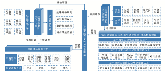
摘要: 梳理了空域容量的基本概念,回顾了空域容量评估方法研究的起源与发展历程,总结了4种典型空域容量评估方法(基于数学计算模型的评估方法、基于管制员工作负荷的雷达模拟机评估方法、基于计算机仿真模型的评估方法与基于数据驱动的评估方法)的主要研究成果,结合中国空域管理现状与改革需求,提出了低空空域容量评估框架,分别介绍了低空空域分类与航路划设、起降机场选址布局与容量评估、低空空域容量影响因素分析以及低空空域容量评估方法相关内容,结合未来发展趋势提出了展望。研究结果表明:低空空域分类与划设是容量评估的基本前提,应充分考虑低空空域环境的复杂性,结合航空器性能、应用场景科学规划;起降机场是低空空域环境的关键节点,场点选址与内部结构将直接影响整体低空空域容量水平;低空空域容量影响因素分析是关键步骤,发挥着与低空空域容量评估结果相互验证的作用;目前,尚未形成成熟的低空空域容量评估方法体系,重点介绍了3种方法,分别为基于阈值的空域容量评估方法、基于几何拓扑的空域容量评估方法以及基于控制变量的空域容量评估方法;总体来说,低空空域容量评估是实现低空空域资源合理配置、保证低空空域运行安全高效的重要内容,应结合中国空域管理特点,开展因地制宜的低空空域容量评估方法研究与试点验证。Abstract: The basic definition of airspace capacity was combed. The origin and development of airspace capacity evaluation methodology research were reviewed. The main findings of four typical airspace capacity evaluation methods (evaluation method based on mathematical calculation models, radar simulator evaluation method based on controller workloads, evaluation method based on computer simulation modeling, and evaluation method based on data-driven) were summarized. Combined with the current situation and reform needs of China's airspace management, a framework for the low-altitude airspace capacity evaluation was proposed. The low-altitude airspace classification and air route planning, landing and take-off airport location layout and capacity evaluation, influencing factors analysis and evaluation methods of low-altitude airspace capacity were introduced, respectively. Future development trend was predicted. Research results show that the classification and planning of low-altitude airspace is the basic premise of capacity evaluation, and the complexity of the low-altitude airspace environment should be fully considered, combined with the performance of aircraft and scientific planning of application scenarios. Landing and take-off airports are key nodes in the low-altitude airspace environment. The site location and internal structure will directly affect the overall low-altitude airspace capacity level. The influencing factors analysis on the low-altitude airspace capacity is a key step and serves as a cross-validation with the results of low-altitude airspace capacity evaluation. At present, a mature methodological system for the low-altitude airspace capacity evaluation has not been developed. Three methods are mainly introduced, which are the threshold-based airspace capacity evaluation method, geometrical topology-based airspace capacity evaluation method, and control-variable-based airspace capacity evaluation method. In general, the low-altitude airspace capacity evaluation is an important content to realize the rational allocation of low-altitude airspace resources and ensure the safe and efficient low-altitude airspace operation, and it should be combined with the characteristics of China's airspace management to carry out locally adapted research on the low-altitude airspace capacity evaluation method and pilot validation.
-

图 4 基于几何拓扑的空域容量评估方法流程
Figure 4. Flow of geometrical topology-based airspace capacity evaluation method
表 1 空域容量定义
Table 1. Definition of airspace capacity
类别 定义 常用方法 运行容量/实际容量 特定空域环境在可接受的延误水平下,单位时间内能够服务的最大航空器架次 基于计算机仿真模型的评估方法
基于管制员工作负荷的雷达模拟机评估方法最大容量 特定空域环境在延误趋向于无穷大时,单位时间内能够服务的最大航空器架次,通常大于运行容量 基于计算机仿真模型的评估方法
基于管制员工作负荷的雷达模拟机评估方法
基于数据驱动的评估方法
基于数学计算模型的评估方法(跑道)航班时刻安排容量 每小时航班时刻表安排的最大航班量,通常小于运行容量 依据空管、机场等单位保障能力确定  下载: 导出CSV
表 2 空域容量评估方法对比
Table 2. Comparison of airspace capacity evaluation methods
空域容量评估方法 优点 不足 基于数学计算模型的评估方法 起源较早,基本成熟,投入较少,评估结果较为准确 主要应用于机场跑道,无法刻画飞机飞行速度等影响因素对容量水平的影响 基于管制员工作负荷的雷达模拟机评估方法 操作相对简单,评估结果较为准确 管制员表现的差异性会直接影响评估结果 基于计算机仿真模型的评估方法 可表征气象等随机影响因素对空域容量的影响,较好地复现真实空域环境 投入成本高,研发周期长 基于数据驱动的评估方法 可对机场整体运行情况进行较为准确的评估 数据误差或缺失直接影响评估结果的准确性
下载: 导出CSV
表 3 空域仿真软件
Table 3. Airspace simulation softwares
软件名称 开发机构 功能特点 SIMMOD 美国联邦航空局 精细度高,可实现机场以及终端区结构下,对空域规划、航空器进离港、航空器滑行、人为因素、突发情况等多场景仿真;复杂度高,对操作者有专业技术和基础知识要求 TAAM 澳大利亚民用航空局杰普森公司 灵活全面,既可实现对全空域系统的仿真,也可针对某一特定结构或流程,支持连接TAAM全球航空导航数据;流程复杂,对数据量有一定的要求 RAMS 欧洲航行安全组织实验中心ISA软件公司 快速有效,可实现对空中交通管制员工作负荷的统计评估,可输出交通密度、飞行冲突、交通流量等多指标统计结果;通用性较弱,对数据格式与质量有一定的要求 AirTop 比利时Airtopsoft公司 功能全面,主要面向空中交通复杂度研究,界面友好,操作快捷,是现阶段行业内认可度较高的空域仿真软件
下载: 导出CSV
表 4 低空空域容量评估方法特点分析
Table 4. Analysis of characteristics of low-altitude airspace capacity evaluation methods
低空空域容量评估方法 优点 不足 基于阈值的空域容量评估方法 面向低空航空器自由飞行场景,不受空域结构限制 较为理想化,尚未考虑地形、建筑物等影响因素对低空空域容量水平的影响 基于几何拓扑的空域容量评估方法 有效利用了无人机地理围栏技术,实现了城市高密度区域可用空域的识别 地理围栏半径选取直接影响评估结果;尚未考虑无人机飞行规则、空域结构等影响因素 基于控制变量的空域容量评估方法 考虑了空域结构、交通密度、城市交通潮汐特点等影响因素 忽略了建筑物的影响,假设航空器均在建筑物上方运行
下载: 导出CSV
表 5 文献总结
Table 5. Literature review
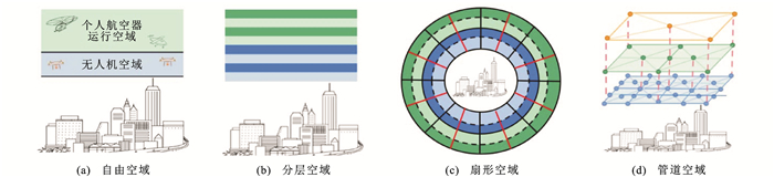
体系要素 主要贡献/技术 文献编号 所属机构 低空空域的分类与航路划设 低空空域分类 基于预先规划的4D航迹, 提出了自由、分层、扇形、管道4种空域结构概念 [22] 代尔夫特理工大学 为了加强小型无人机系统的安全集成, 提出将美国G类空域垂直分为低速区(60.96 m以下)、高速区(60.96~121.92 m)、禁飞区(121.92~152.40 m) [71] 亚马逊 运用电子围栏技术实现了无人机可航行空域与障碍物的隔离 [74] 韩国高级科学技术学院 航路网络划设 基于城市三维数据构建了矩阵节点型、建筑物节点型、道路沿线型3种构型的低空航路网络 [8] 南洋理工大学 提出低空公共航线网络概念, 运用改进蚁群算法构建了天津区域的低空公共航路 [81] 中国科学院地理科学与资源研究所 起降机场的选址布局与容量 场址选择 基于地理信息数据, 面向eVTOL运行场景, 运用加权线性组合方法提出了一种城市空中交通地面基础设施选址方法 [87] 慕尼黑工业大学 基于上海某区域地理信息与物流需求数据, 采用人类学习优化算法, 实现了对该区域的物流无人机多级起降点布局规划 [96] 南京航空航天大学 内部布局 设计了单拓扑、线性拓扑、卫星拓扑、码头拓扑4种垂直起降机场内部构型, 通过可能产生的吞吐量辅助布局过程 [97] 慕尼黑航空 场址容量 提出了一种基于整数规划的垂直起降机场容量评估方法, 对滑行道、停机坪等基础设施与容量水平的关系进行了分析 [100] 麻省理工学院 将排队论引入垂直起降机场容量评估中, 提出了一种可接受延误水平下的垂直起降机场实际容量评估方法 [101] 南京航空航天大学 低空容量影响因素分析 空域结构 通过仿真试验表明分层空域结构最为合理 [22] 代尔夫特理工大学 通导监覆盖水平 随着通导监视技术发展, 低空空域容量也将随之提升 [69] 美国航空航天局 运行间隔 面向自由运行场景, 研究了安全距离设定下, 交通密度和飞行冲突的关系 [103] 加利福尼亚大学伯克利分校 分别面向机构化空域与非结构化空域, 提出了基于碰撞概率的无人机安全间隔标定方法 [104] 南京航空航天大学 低空空域容量评估技术研究 基于阈值的空域容量评估技术 提出了冲突集群大小和归一化冲突时间2种指标表征空中交通复杂度, 以旧金山湾区为场景搭建仿真平台, 提出未来该区域无人机飞行可达到日均100 000架次 [103] 加利福尼亚大学伯克利分校 基于几何拓扑的空域容量评估技术 通过禁止飞入地理围栏和禁止飞出地理围栏技术, 从可用空域识别的角度对城市空域容量进行了分析 [74] 韩国高级科学技术学院 基于控制变量的空域容量评估方法 通过交通管理软件, 开展大规模仿真试验, 实现了对从分散化到结构化等4种空域结构的容量评估 [22] 代尔夫特理工大学
下载: 导出CSV
-
[1] 周雄飞, 胡明华. 空域容量评估研究综述[J]. 中国民航飞行学院学报, 2016, 27(6): 37-40.ZHOU Xiong-fei, HU Ming-hua. An overview on airspace capacity evaluation[J]. Journal of Civil Aviation Flight University of China, 2016, 27(6): 37-40. (in Chinese) [2] BOWEN E, PEARCEY T. Delays in the flow of air traffic[J]. The Aeronautical Journal, 1948, 52(448): 251-258. [3] FAA. FACT1: capacity needs in the national airspace system[R]. Washington DC: FAA, 2004. [4] FAA. FACT2: capacity needs in the national airspace system[R]. Washington DC: FAA, 2007. [5] FAA. FACT3: airport capacity needs in the national airspace system[R]. Washington DC: FAA, 2015. [6] BULUSU V, SENGUPTA R, POLISHCHUK V, et al. Cooperative and non-cooperative UAS traffic volumes[C]//IEEE. 2017 International Conference on Unmanned Aircraft Systems (ICUAS). New York: IEEE, 2017: 1673-1681. [7] BULUSU V, POLISHCHUK V. A threshold based airspace capacity estimation method for UAS traffic management[C]// IEEE. 2017 Annual IEEE International Systems Conference. New York: IEEE, 2017: 1-7. [8] SALLEH M F B, CHI Wan-chao, WANG Zhen-kun, et al. Preliminary concept of adaptive urban airspace management for unmanned aircraft operations[C]//AIAA. 2018 AIAA Information Systems Infotech@Aerospace. Reston: AIAA, 2018: 1-12. [9] 全权, 李刚, 柏艺琴, 等. 低空无人机交通管理概览与建议[J]. 航空学报, 2020, 41(1): 323238.QUAN Quan, LI Gang, BAI Yi-qin, et al. Low altitude UAV traffic management: an introductory overview and proposal[J]. Acta Aeronautica et Astronautica Sinica, 2020, 41(1): 323238. (in Chinese) [10] PEARCEY T. Delays in landing of air traffic[J]. Aeronautical Journal, 1950, 52(456): 799-812. [11] BLUMSTEIN A. The landing capacity of a runway[J]. Operations Research, 1959, 7(6): 752-763. doi: 10.1287/opre.7.6.752 [12] HOOTON E N, GALLIHER H P, WARSKOW M A, et al. Operational evaluation of airport runway design and capacity: a study of methods and techniques[R]. New York: DTIC, 1963. [13] RATNER R S, SIDDIQUEE W, GLASER M B, et al. A methodology for evaluating the capacity of air traffic control systems[R]. Menlo Park: Stanford Research Institute, 1970. [14] JANIC M, TOSIC V. Terminal airspace capacity model[J]. Transportation Research Part A: General, 1982, 16(4): 253-260. doi: 10.1016/0191-2607(82)90052-8 [15] JANIC M, TOSIC V. En route sector capacity model[J]. Transportation Science, 1991, 25(4): 299-307. doi: 10.1287/trsc.25.4.299 [16] FAA. Airport capacity and delay[R]. Washington DC: FAA, 1983. [17] TOFUKUJI N. An enroute ATC simulation experiment for sector capacity estimation[J]. IEEE Transactions on Control Systems Technology, 1993, 1(3): 138-143. doi: 10.1109/87.251881 [18] GILBO E P. Airport capacity: representation, estimation, optimization[J]. IEEE Transactions on Control Systems Technology, 1993, 1(3): 144-154. doi: 10.1109/87.251882 [19] WANG Chao, ZHANG Xin-yue, XU Xiao-hao. Simulation study on airfield system capacity analysis using SIMMOD[C]// IEEE. 2008 International Symposium on Computational Intelligence and Design. New York: IEEE, 2008: 87-90. [20] MAJUMDAR A, OCHIENG W, POLAK J. Estimation of European airspace capacity from a model of controller workload[J]. Journal of Navigation, 2002, 55(3): 381-403. doi: 10.1017/S037346330200190X [21] 温媛媛, 戴福青. 基于TAAM机场终端区容量评估方法研究[J]. 中国民航飞行学院学报, 2013, 24(6): 9-14.WEN Yuan-yuan, DAI Fu-qing. Terminal area capacity assessment based on TAAM[J]. Journal of Civil Aviation Flight University of China, 2013, 24(6): 9-14. (in Chinese) [22] SUNIL E, HOEKSTRA J M, ELLERBROEK J, et al. Metropolis: relating airspace structure and capacity for extreme traffic densities[C]//FAA. Proceedings of the 11th USA/Europe Air Traffic Management Research and Development Seminar (ATM2015). Washington DC: FAA, 2015: 23-26. [23] SWEDISH W J. Upgraded FAA airfield capacity model, Volume 1: supplemental users guide[R]. Washington DC: FAA, 1981. [24] SWEDISH W J. Upgraded FAA airfield capacity model, Volume 2: technical description of revisions[R]. Washington DC: FAA, 1981. [25] LEE D A, KOSTIUK P F, HEMM R V, et al. Estimating the effects of the terminal area productivity programs[R]. Washington DC: NASA, 1997. [26] LEE D A, NELSON C, SHAPIRO G. The aviation system analysis capability airport capacity and delay models[R]. Washington DC: NASA, 1998. [27] STAMATOPOULOS M A, ZOGRAFOS K G, ODONI A R. A decision support system for airport strategic planning[J]. Transportation Research Part C: Emerging Technologies, 2004, 12(2): 91-117. doi: 10.1016/j.trc.2002.10.001 [28] 田勇. 空中交通流量管理关键技术研究[D]. 南京: 南京航空航天大学, 2011.TIAN Yong. Research on key techniques of air traffic flow management[D]. Nanjing: Nanjing University of Aeronautics and Astronautic, 2011. (in Chinese) [29] 冯晓磊, 唐鹤丹, 李明捷. 错列平行双跑道容量评估模型研究[J]. 数学的实践与认识, 2017, 47(11): 66-73.FENG Xiao-lei, TANG He-dan, LI Ming-jie. Research on the capacity evaluation model of staggered parallel double runways[J]. Mathematics in Practice and Theory, 2017, 47(11): 66-73. (in Chinese) [30] LI Xiong, LI Feng, CHEN Xiao-qing. Study on the configuration and capacity of the lateral runway based on the airport green operation[C]//IOP Publishing. 2017 International Conference on Environmental and Energy Engineering. Ostrava: IOP Publishing, 2017: 012032-1-8. [31] 沈志远, 胡莹莹. 考虑尾流影响的侧向双跑道机场的跑道容量研究[J]. 南京航空航天大学学报, 2020, 52(1): 161-170.SHEN Zhi-yuan, HU Ying-ying. Runway capacity of lateral double-runway airport considering wake effect[J]. Journal of Nanjing University of Aeronautics and Astronautics, 2020, 52(1): 161-170. (in Chinese) [32] 刘珂璇, 马兰. 隔离运行模式下开口V形跑道容量评估模型[J]. 中国科技论文, 2018, 13(7): 825-830. doi: 10.3969/j.issn.2095-2783.2018.07.019LIU Ke-xuan, MA Lan. Capacity assessment of two open Ⅴ-shaped runways based on isolated operation mode[J]. China Sciencepaper, 2018, 13(7): 825-830. (in Chinese) doi: 10.3969/j.issn.2095-2783.2018.07.019 [33] 冯奎奎, 翟文鹏, 王玮卿. 基于排队模型的乌鲁木齐机场容量评估[J]. 数学的实践与认识, 2019, 49(21): 1-8.FENG Kui-kui, ZHAI Wen-peng, WANG Wei-qing. Capacity evaluation of Urumqi Airport based on queuing model[J]. Mathematics in Practice and Theory, 2019, 49(21): 1-8. (in Chinese) [34] CHEUNG W L, PIPLANI R, ALAM S, et al. Dynamic capacity and variable runway configurations in airport slot allocation[J]. Computers and Industrial Engineering, 2021, 159: 107480. doi: 10.1016/j.cie.2021.107480 [35] MIRKOVIC B, TOSIC V. Airport apron capacity: estimation, representation, and flexibility[J]. Journal of Advanced Transportation, 2014, 48(2): 97-118. doi: 10.1002/atr.1250 [36] MIRKOVIC B. Airport apron capacity estimation-model enhancement[J]. Procedia-Social and Behavioral Sciences, 2011, 20: 1108-1117. doi: 10.1016/j.sbspro.2011.08.120 [37] CAI Kai-quan, LI Wei, JU Fei, et al. A scenario-based optimization approach to robust estimation of airport apron capacity[C]//IEEE. 2018 Integrated Communications, Navigation, Surveillance Conference (ICNS). New York: IEEE, 2018: 3A1-1-3A1-8. [38] LIAO Chen-xi, WEI Zheng. Study on sector capacity and workload model of air traffic controllers based on least square method[C]//IEEE. 2020 IEEE International Conference on Power, Intelligent Computing and Systems (ICPICS). New York: IEEE, 2020: 1058-1062. [39] WELCH J D, ANDREWS J W, MARTIN B D, et al. Macroscopic workload model for estimating en route sector capacity[C]//FAA. Proceedings of 7th USA/Europe ATM Research and Development Seminar. Washington DC: FAA, 2007: 1-17. [40] TIAN Yong, WAN Li-li, YANG Shuang-shuang. Research on the method of sector dynamic capacity evaluation[J]. System Engineering—Theory and Practice, 2014, 34(8): 2163-2169. [41] 罗凤娥, 齐放, 赵琪, 等. 基于改进的DORATASK飞行签派员工作负荷评估[J]. 科技和产业, 2021, 21(4): 240-243.LUO Feng-e, QI Fang, ZHAO Qi, et al. Flight dispatcher workload assessment based on improved DORATASK[J]. Science Technology and Industry, 2021, 21(4): 240-243. (in Chinese) [42] 董襄宁. 扇区容量评估及复杂性分析[D]. 南京: 南京航空航天大学, 2017.DONG Xiang-ning. Sector capacity evaluation and complexity analysis[D]. Nanjing: Nanjing University of Aeronautics and Astronautics, 2017. (in Chinese) [43] KAGEYAMA K. ATC procedures modeling for capacity estimation of Japanese airspace[C]//AIAA. 2017 AIAA Modeling and Simulation Technologies Conference. Reston: AIAA, 2017: 1-10. [44] ZHANG Ming, SHAN Le, LIU Kai, et al. Terminal airspace sector capacity estimation method based on the ATC dynamical model[J]. Kybernetes, 2016, 45(6): 884-899. [45] MAJEED M, SU Rong. Neural partial differentiation-based estimation of terminal airspace sector capacity[J]. SAE International Journal of Aerospace, 2021, 14(2): 203-217. [46] 任广建, 朱金福, 卢朝阳. 基于ES模型的扇区容量评估研究[J]. 航空计算技术, 2018, 48(6): 40-44.REN Guang-jian, ZHU Jin-fu, LU Chao-yang. Research on assessment method of sector capacity based on ES model[J]. Aeronautical Computing Technique, 2018, 48(6): 40-44. (in Chinese) [47] 张文倩, 王瑛, 严伟, 等. 恶劣天气下的多扇区动态容量评估方法[J]. 火力与指挥控制, 2019, 44(3): 126-130, 140.ZHANG Wen-qian, WANG Ying, YAN Wei, et al. Research on multi-sector dynamic capacity evaluation method in severe weather[J]. Fire Control and Command Control, 2019, 44(3): 126-130, 140. (in Chinese) [48] LIU Lu. Terminal airspace capacity evaluation model under weather condition from perspective of a controller[J]. International Journal of Aerospace Engineering, 2018(2): 1-11. [49] 黄海清, 甘旭升, 丁黎颖, 等. 军事活动影响下的终端区容量评估方法研究[J]. 航空工程进展, 2020, 11(3): 344-352.HUANG Hai-qing, GAN Xu-sheng, DING Li-ying, et al. Study on capacity assessment method of terminal area under the influence of military activities[J]. Advances in Aeronautical, Science and Engineering, 2020, 11(3): 344-352. (in Chinese) [50] 刘璐. 气象影响下终端区空域短期容量预测研究[D]. 南京: 南京航空航天大学, 2018.LIU Lu. Research on short-term terminal capacity assessment under weather conditions[D]. Nanjing: Nanjing University of Aeronautics and Astronautics, 2018. (in Chinese) [51] 王笑天, 白乃贵. 基于AirTop的武汉天河国际机场空域容量仿真评估[J]. 飞机设计, 2018, 38(1): 72-75.WANG Xiao-tian, BAI Nai-gui. Airspace capacity simulation evaluation of Wuhan Tianhe International Airport based on AirTop[J]. Aircraft Design, 2018, 38(1): 72-75. (in Chinese) [52] 高伟, 康道驰. 基于增维细胞传输模型的区域管制空域容量评估[J]. 科学技术与工程, 2020, 20(29): 12211-12217.GAO Wei, KANG Dao-chi. Regional controlled airspace capacity assessment based on an augmented cell transport model[J]. Science Technology and Engineering, 2020, 20(29): 12211-12217. (in Chinese) [53] 孙海勇, 刘裕旭. 不同运行模式下的远距平行跑道容量研究[J]. 航空计算技术, 2019, 49(5): 59-62, 66.SUN Hai-yong, LIU Yu-xu. Research on long parallel runway capacity in different operation modes[J]. Aeronautical Computing Technique, 2019, 49(5): 59-62, 66. (in Chinese) [54] 王强, 左杰俊, 钟琦, 等. 基于AnyLogic仿真的中小机场容量评估分析[J]. 航空计算技术, 2020, 50(3): 21-24.WANG Qiang, ZUO Jie-jun, ZHONG Qi, et al. Capacity evaluation analysis of small and medium airports based on AnyLogic simulation[J]. Aeronautical Computing Technique, 2020, 50(3): 21-24. (in Chinese) [55] PARAMBATH S K. Capacity of ATC sectors in Chennai Upper Area Control Centre[C]//IEEE. 2020 IEEE International Conference on Electronics, Computing and Communication Technologies (CONECCT). New York: IEEE, 2020: 1-7. [56] RAMAMOORTHY K, HUNTER G. Simulation-based airport capacity estimation[C]//NASA. 2013 Aviation Technology, Integration, and Operations Conference. Washington DC: NASA, 2013: 14-28. [57] BARRER J, KUZMINSKI P, SWEDISH W. Analyzing the runway capacity of complex airports[C]//AIAA. 5th ATIO and 16th Lighter-Than-Air Systems Technology. and Balloon Systems Conferences. Reston: AIAA, 2005: 1-7. [58] 胡青云. 基于复杂空域的多机场终端区扇区优化研究[D]. 广汉: 中国民用航空飞行学院, 2020.HU Qing-yun. Research on sector optimization of multi-airport terminal area based on complex airspace[D]. Guanghan: Civil Aviation Flight University of China, 2020. (in Chinese) [59] 赵征. 空域容量评估与预测技术研究[D]. 南京: 南京航空航天大学, 2015.ZHAO Zheng. Research on airspace capacity assessment and forecast[D]. Nanjing: Nanjing University of Aeronautics and Astronautics, 2015. (in Chinese) [60] 赵征, 胡明华. 机场历史高峰服务能力评估方法研究[J]. 航空计算技术, 2015, 45(1): 17-21.ZHAO Zheng, HU Ming-hua. Research on peak service rate of airport[J]. Aeronautical Computing Technique, 2015, 45(1): 17-21. (in Chinese) [61] LYU Zhi-han, SONG Hou-bing, BASANTA-VAL P, et al. Next-generation big data analytics: state of the art, challenges, and future research topics[J]. IEEE Transactions on Industrial Informatics, 2017, 13(4): 1891-1899. http://discovery.ucl.ac.uk/10043069/1/Review%20on%20Network%20Big%20Data_v6.pdf [62] ZHANG Kai, LIU Yong-xin, WANG Jian, et al. Tree-based airspace capacity estimation[C]//IEEE. 2020 Integrated Communications Navigation and Surveillance Conference (ICNS). New York: IEEE, 2020: 5C1-1-5C1-8. [63] 莫凡. 基于机器学习的扇区容量评估方法研究[D]. 南京: 南京航空航天大学, 2020.MO Fan. Research on sector capacity evaluation method based on machine learning[D]. Nanjing: Nanjing University of Aeronautics and Astronautics, 2020. (in Chinese) [64] CHEN Jia-tong, CAI Kai-quan, LI Wei, et al. An airspace capacity estimation model based on spatio-temporal graph convolutional networks considering weather impact[C]//IEEE. 2021 IEEE/AIAA 40th Digital Avionics Systems Conference (DASC). New York: IEEE, 2021: 1-7. [65] 胡锦文, 程炜. 江西通航产业高质量发展研究[J]. 合作经济与科技, 2022, 692(21): 10-12.HU Jin-wen, CHENG Wei. Study on the high quality development of Jiangxi general aviation industry[J]. Co-Operative Economy and Science, 2022, 692(21): 10-12. (in Chinese) [66] 张洪海, 邹依原, 张启钱, 等. 未来城市空中交通管理研究综述[J]. 航空学报, 2021, 42(7): 82-106.ZHANG Hong-hai, ZOU Yi-yuan, ZHANG Qi-qian, et al. Future urban air mobility management: review[J]. Acta Aeronautica et Astronautica Sinica, 2021, 42(7): 82-106. (in Chinese) [67] 李诚龙, 屈文秋, 李彦冬, 等. 面向eVTOL航空器的城市空中运输交通管理综述[J]. 交通运输工程学报, 2020, 20(4): 35-54. doi: 10.19818/j.cnki.1671-1637.2020.04.003LI Cheng-long, QU Wen-qiu, LI Yan-dong, et al. Overview of traffic management of urban air mobility (UAM) with eVTOL aircraft[J]. Journal of Traffic and Transportation Engineering, 2020, 20(4): 35-54. (in Chinese) doi: 10.19818/j.cnki.1671-1637.2020.04.003 [68] 张洪海, 李姗, 夷珈, 等. 城市低空航路规划研究综述[J]. 南京航空航天大学学报, 2021, 53(6): 827-838.ZHANG Hong-hai, LI Shan, YI Jia, et al. Review on urban low-altitude air route planning[J]. Journal of Nanjing University of Aeronautics and Astronautics, 2021, 53(6): 827-838. (in Chinese) [69] MUELLER E R. Enabling airspace integration for high density urban air mobility[R]. Washington DC: NASA, 2017. [70] 陈义友, 张建平, 邹翔, 等. 民用无人机交通管理体系架构及关键技术[J]. 科学技术与工程, 2021, 21(31): 13221-13237.CHEN Yi-you, ZHANG Jian-ping, ZOU Xiang, et al. System framework and key technologies of civil unmanned aircraft system traffic management[J]. Science Technology and Engineering, 2021, 21(31): 13221-13237. (in Chinese) [71] JIANG Tao, GELLER J, NI Dai-heng, et al. Unmanned aircraft system traffic management: concept of operation and system architecture[J]. International Journal of Transportation Science and Technology, 2016, 5(3): 123-135. [72] HOEKSTRA J M, ELLERBROEK J, SUNIL E, et al. Geovectoring: reducing traffic complexity to increase the capacity of UAV airspace[C]//ICRAT. International Conference for Research in Air Transportation. Barcelona: ICRAT, 2018: 1-8. [73] MOHAMED SALLEH M F B, LOW K H. Concept of operations (ConOps) for traffic management of unmanned aircraft systems (TM-UAS) in urban environment[C]//AIAA. 2017 AIAA Information Systems—AIAA Infotech Aerospace. Reston: AIAA, 2017: 1-13. [74] CHO J, YOON Y. How to assess the capacity of urban airspace: a topological approach using keep-in and keep-out geofence[J]. Transportation Research Part C: Emerging Technologies, 2018, 92: 137-149. [75] 张玉梅, 苑永月. 我国低空空域管理现状与发展策略[J]. 电子技术, 2020, 49(7): 104-105.ZHANG Yu-mei, YUAN Yong-yue. Situation and development strategy of lower altitude airspace management in China[J]. Electronic Technology, 2020, 49(7): 104-105. (in Chinese) [76] 石潇竹. 我国低空空域结构调整与划设探讨[J]. 指挥信息系统与技术, 2010, 1(3): 23-26.SHI Xiao-zhu. Discussion on layout of Chinese low altitude airspace structure[J]. Command Information System and Technology, 2010, 1(3): 23-26. (in Chinese) [77] 高萍, 王古常, 郑幸, 等. 无人机空域飞行的现状及发展趋势[C]//CSAA. 2014(第五届)中国无人机大会论文集. 北京: CSAA, 2014: 638-641.GAO Ping, WANG Gu-chang, ZHENG Xing, et al. Status and development trend of UAV airspace flight[C]//CSAA. 2014 (5th) China UAV Conference Proceedings. Beijing: CSAA, 2014: 638-641. (in Chinese) [78] GHARIBI M, BOUTABA R, WASLANDER S L. Internet of drones[J]. IEEE Access, 2016, 4: 1148-1162. [79] SUNIL E, ELLERBROEK J, HOEKSTRA J, et al. An analysis of decentralized airspace structure and capacity using fast-time simulations[J]. Journal of Guidance, Control and Dynamics, 2017, 40(1): 38-51. [80] ROBERGE V, TARBOUCHI M, LABONTÉ G. Fast genetic algorithm path planner for fixed-wing military UAV using GPU[J]. IEEE Transactions on Aerospace and Electronic Systems, 2018, 54(5): 2105-2117. [81] LIAO Xiao-han, XU Chen-chen, YUE Huan-yin. Enable UAVs safely flight in low-altitude: a preliminary research of the public air route network of UAVs[C]//IEEE. 2019 International Conference on Unmanned Aircraft Systems (ICUAS). New York: IEEE, 2019: 959-964. [82] 张启钱, 许卫卫, 张洪海, 等. 复杂低空物流无人机路径规划[J]. 北京航空航天大学学报, 2020, 46(7): 1275-1286.ZHANG Qi-qian, XU Wei-wei, ZHANG Hong-hai, et al. Path planning for logistics UAV in complex low-altitude airspace[J]. Journal of Beijing University of Aeronautics and Astronautics, 2020, 46(7): 1275-1286. (in Chinese) [83] 唐立, 郝鹏, 张学军. 基于改进蚁群算法的山区无人机路径规划方法[J]. 交通运输系统工程与信息, 2019, 19(1): 158-164.TANG Li, HAO Peng, ZHANG Xue-jun. An UAV path planning method in mountainous area based on an improved ant colony algorithm[J]. Journal of Transportation Systems Engineering and Information Technology, 2019, 19(1): 158-164. (in Chinese) [84] 张洪海, 李翰, 刘皞, 等. 城市区域物流无人机路径规划[J]. 交通运输系统工程与信息, 2020, 20(6): 22-29.ZHANG Hong-hai, LI Han, LIU Hao, et al. Path planning for logistics unmanned aerial vehicle in urban area[J]. Journal of Transportation Systems Engineering and Information Technology, 2020, 20(6): 22-29. (in Chinese) [85] 王云常, 戴朱祥, 李涛. 基于A星算法与人工势场法的无人机路径规划[J]. 扬州大学学报(自然科学版), 2019, 22(3): 36-38, 49.WANG Yun-chang, DAI Zhu-xiang, LI Tao. UAV path planning based on A-star algorithm and artificial potential field method[J]. Journal of Yangzhou University (Natural Science Edition), 2019, 22(3): 36-38, 49. (in Chinese) [86] LIN Xi, WANG Chen-zhang, WANG Kai-ping, et al. Trajectory planning for unmanned aerial vehicles in complicated urban environments: a control network approach[J]. Transportation Research Part C: Emerging Technologies, 2021, 128: 103-120. [87] DIMAS N F. A GIS-based analysis for selecting ground infrastructure locations for urban air mobility[D]. Munich: Environmental Engineering Technical University of Munich, 2018. [88] SHAVARANI S M, NEJAD M G, RISMANCHIAN F, et al. Application of hierarchical facility location problem for optimization of a drone delivery system: a case study of Amazon prime air in the city of San Francisco[J]. The International Journal of Advanced Manufacturing Technology, 2018, 95(9): 3141-3153. [89] 钱欣悦, 张洪海, 张芳, 等. 末端配送物流无人机起降点选址分配问题研究[J]. 武汉理工大学学报(交通科学与工程版), 2021, 45(4): 682-687, 693.QIAN Xin-yue, ZHANG Hong-hai, ZHANG Fang, et al. Research on location allocation of UAV landing points for terminal distribution logistics[J]. Journal of Wuhan University of Technology (Transportation Science and Engineering), 2021, 45(4): 682-687, 693. (in Chinese) [90] GOLABI M, SHAVARANI S M, IZBIRAK G. An edge-based stochastic facility location problem in UAV-supported humanitarian relief logistics: a case study of Tehran Earthquake[J]. Natural Hazards, 2017, 87(3): 1545-1565. [91] 任新惠, 王柳. 即时配送下无人机全自动机场分区选址模型[J]. 计算机工程与应用, 2021, 57(10): 266-272.REN Xin-hui, WANG Liu. Location model of automatic airport partitioning for unmanned aerial vehicles under urban instant delivery[J]. Computer Engineering and Applications, 2021, 57(10): 266-272. (in Chinese) [92] 陈刚, 付江月. 军民融合背景下无人机配送中心选址问题研究[J]. 计算机工程与应用, 2019, 55(8): 226-231, 237.CHEN Gang, FU Jiang-yue. Drone distribution center location problem under military-civilian integration strategy[J]. Computer Engineering and Applications, 2019, 55(8): 226-231, 237. (in Chinese) [93] HONG I, KUBY M, MURRAY A T. A range-restricted recharging station coverage model for drone delivery service planning[J]. Transportation Research Part C: Emerging Technologies, 2018, 90: 198-212. [94] CHAUHAN D, UNNIKRISHNAN A, FIGLIOZZI M. Maximum coverage capacitated facility location problem with range constrained drones[J]. Transportation Research Part C: Emerging Technologies, 2019, 99: 1-18. [95] VENKATESH N, PAYAN A P, JUSTIN C Y, et al. Optimal siting of sub-urban air mobility (sUAM) ground architectures using network flow formulation[C]//AIAA. AIAA Aviation 2020 Forum. Reston: AIAA, 2020: 1-19. [96] 张洪海, 冯棣坤, 张晓玮, 等. 城市物流无人机起降点布局规划研究[J]. 交通运输系统工程与信息, 2022, 22(3): 207-214.ZHANG Hong-hai, FENG Di-kun, ZHANG Xiao-wei, et al. Urban logistics unmanned aerial vehicle vertiports layout planning[J]. Journal of Transportation Systems Engineering and Information Technology, 2022, 22(3): 207-214. (in Chinese) [97] PREIS L. Quick sizing, throughput estimating and layout planning for vtol aerodromes—a methodology for vertiport design[C]//AIAA. AIAA Aviation 2021 Forum. Reston: AIAA, 2021: 1-19. [98] EASA. Prototype technical design specifications for vertiports[R]. Cologne: EASA, 2022. [99] FAA. Engineering brief No. 105 vertiport design[R]. Washington DC: FAA, 2022. [100] VASCIK P D, HANSMAN R J. Development of vertiport capacity envelopes and analysis of their sensitivity to topological and operational factors[C]//AIAA. AIAA Scitech 2019 Forum. Reston: AIAA, 2019: 1-26. [101] ZHANG Hong-hai, FEI Yu-han, LI Jing-yu, et al. Method of vertiport capacity assessment based on queuing theory of unmanned aerial vehicles[J]. Sustainability, 2023, 15(1): 709-732. [102] RIMJHA M, TRANI A. Urban air mobility: factors affecting vertiport capacity[C]//IEEE. 2021 Integrated Communications Navigation and Surveillance Conference (ICNS). New York: IEEE, 2021: 1-14. [103] BULUSU V, SENGUPTA R, LIU Zhi-long. Unmanned aviation: to be free or not to be free?[C]//FAA. 7th International Conference on Research in Air Transportation. Washington DC: FAA, 2016: 1-8. [104] 邹依原. 智慧城市环境下无人机安全间隔标定方法研究[D]. 南京: 南京航空航天大学, 2021.ZOU Yi-yuan. Research on the demarcation method of safe separation for unmanned aerial vehicle in future smart cities[D]. Nanjing: Nanjing University of Aeronautics and Astronautics, 2021. (in Chinese) [105] BULUSU V, POLISHCHUK V, SENGUPTA R, et al. Capacity estimation for low altitude airspace[C]//AIAA. 17th AIAA Aviation Technology, Integration, and Operations Conference. Reston: AIAA, 2017: 4266. [106] BULUSU V, SENGUPTA R, MUELLER E R, et al. A throughput based capacity metric for low-altitude airspace[C]// AIAA. 2018 Aviation Technology, Integration, and Operations Conference. Reston: AIAA, 2018: 1-9. -


 点击查看大图
计量
- 文章访问数: 425
- HTML全文浏览量: 59
- PDF下载量: 110
- 被引次数: 0
